Originally published at: Since our weather is fairly calm, lets talk about this looming ‘super’ El Niño – Space City Weather
In brief: In today’s post we discuss the looming El Niño, and what it means for Houston if it becomes a “super” El Niño this winter. We also discuss our sunny days heading into the weekend, and the potential for rain on Sunday and next week.
Here comes El Niño
It is not quite here yet, but in the coming weeks (perhaps even days) we are likely to see temperatures in the equatorial Pacific flip over to El Niño conditions, which is defined by average temperatures in a certain area of the Pacific reaching 0.5 degrees C above usual conditions. (Conversely, La Niña occurs when temperatures in this region fall 0.5 degrees below normal). We experience a handful of El Niños a decade, so it’s not a huge deal. But there has been a lot of buzz about this particular El Niño because it is expected to become unusually strong (as defined by 2.0 degrees C or higher above normal). Here’s a look at the latest spread in the model data, released this week:
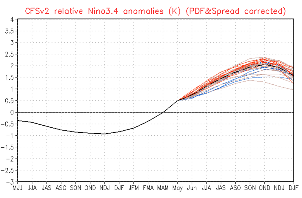
Now, what to make of this? If the bottom legend is confusing, the letters simply represent three months, so when El Niño is forecast to peak it says “OND,” which means October, November, and December of this year. So about four or five months from now. I believe there will be three major impacts for the greater Houston region from El Niño over the coming year, so let’s discuss them.
First up is a beneficial one. By August and September of this year we are likely to see a rapidly strengthening El Niño. You may remember in our Atlantic hurricane season outlook published last week, we spoke about El Niño’s likely increase of wind shear in the Atlantic, which should help reduce the overall number of named storms this year. So by and large, that’s beneficial.
Secondly, depending on when El Niño occurs, it has widely variable impacts on precipitation around the world. For the southern United States, including Texas, the impacts are most pronounced during the winter and early spring months. During this time frame El Niño increases the likelihood of precipitation.
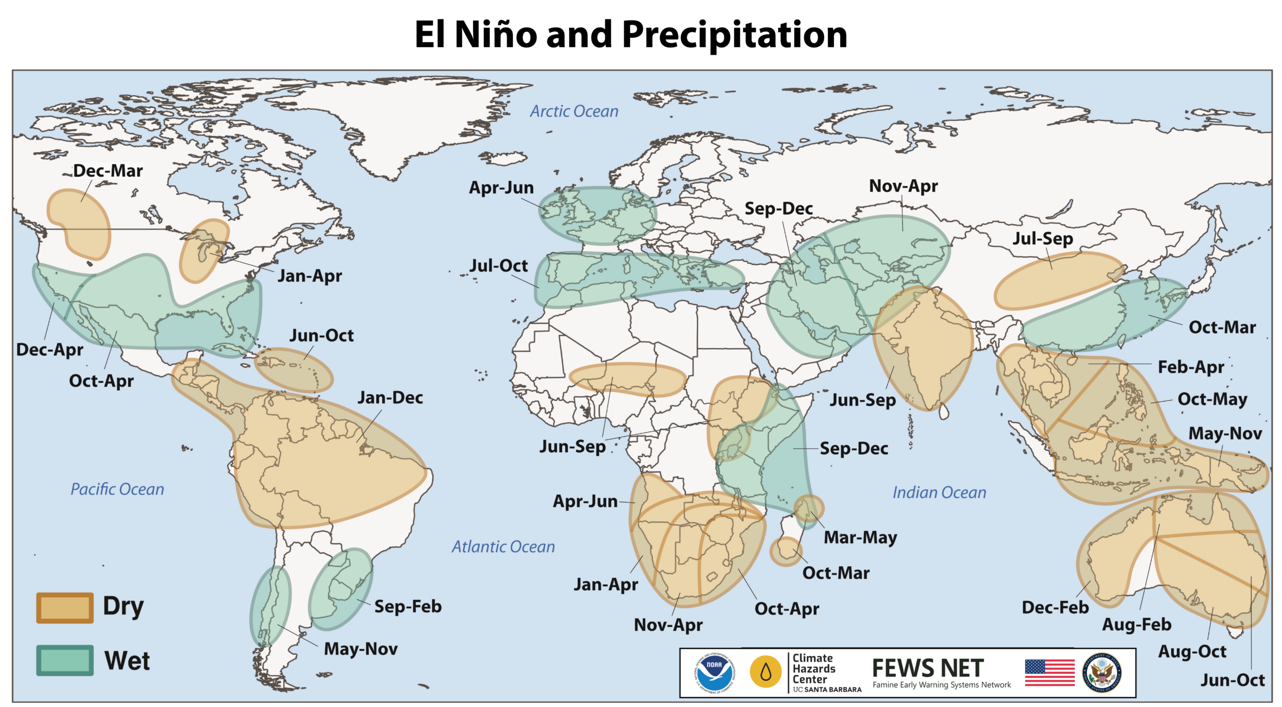
So again, for Texas, this is probably beneficial. We typically don’t get flooding conditions in the winter months, so additional rainfall (or snow?!?) from El Niño probably won’t be a bad thing. And we’re not talking huge changes here. It might be that Houston receives 4.5 inches of rain next February instead of 3.5, or something like that.
As you can see from the initial chart above, El Niño may start to wane next spring, and if history is any guide it probably will start to peter out heading into next summer. However, we have often seen something of a temperature ‘hangover’ following strong El Niños. I am speculating a little bit here, but my guess is that as a result we see a spike in global temperatures that lingers into next summer, and we could see some record-breaking heat in Texas at that time. But that’s a long way off. I can’t even tell you whether it’s going to rain this coming Sunday for certain. Speaking of which, let’s get to the forecast.
Wednesday
With high pressure more or less in place for the next several days Houston will remain in a mostly sunny, steamy pattern. For us that means temperatures generally in the low 90s, with slightly hotter conditions possible inland, and slightly cooler daytime conditions near the coast. Skies will be mostly sunny this afternoon, with just a very slight (10 or 20 percent) chance of a brief shower or downpour. Low temperatures may briefly fall below 80 degrees in Houston, but the reprieve won’t last long. Winds will generally be from the south at about 10 mph, but may gust up to about 20 mph during the afternoon hours.
Thursday, Friday, and Saturday
The rest of the week is likely to see similar conditions, so basically it will feel pretty much like typical June weather out there. Get your sunshine on, Houston.
Sunday
At some point this weekend the high pressure influencing our weather will shift further to the south, opening up our region to the potential for more widespread showers and possibly some thunderstorms. Now I still expect mostly sunny skies on Sunday, but our chances for precipitation will be on the increase. At this point I expect about a 50 percent chance, give or take, however it is possible this number shifts higher (or lower). I don’t expect anything too crazy in terms of accumulations, but given that Houston hosts a World Cup game on Sunday afternoon, we’ll continue to watch for the likelihood of rain before, during, and after the game given all of the festivities around town.
Next week
For much of next week we likely will see partly to mostly cloudy days, with an increased chance of rain for several days. A weak front will move into Texas, but it probably (although not certainly) will die before making its way into Houston. Regardless, after this week’s sunshine a somewhat rainier pattern returns to help keep everything green.