So this summer, it's going to be bad right?

Originally published at: So this summer, it’s going to be bad right? – Space City Weather

In brief: In today’s post we take a look at the likely development of El Niño, and what that means for this summer, as well as next year. We also report on a forecast this week that will bring a lot of sunshine to Houston before a weak front arrives this weekend.

El Niño looms, and what it means for summer

It is becoming increasingly likely that a warmer phase of the tropical Pacific Ocean, known as El Niño, is likely to develop later this year, possibly by the summer. Although localized to the Pacific Ocean, the periodic warming and cooling there has global impacts, including providing upward pressure on global temperatures (The Climate Brink has a good overview of this). The latest modeling suggests that the El Niño likely to peak later this year will be a rather strong one, potentially one of the two strongest experienced during the last 40 years.

At this point you might be expecting me to say something like, with such a strong El Niño the United States will probably experience its warmest summer on record. And while that is possible, I would point out that the response from global surface temperatures typically lags the peak of El Niño by a couple of months, and right now I don’t expect it to peak until the end of this year. So the summer of 2027? Yeah, probably brutally hot.

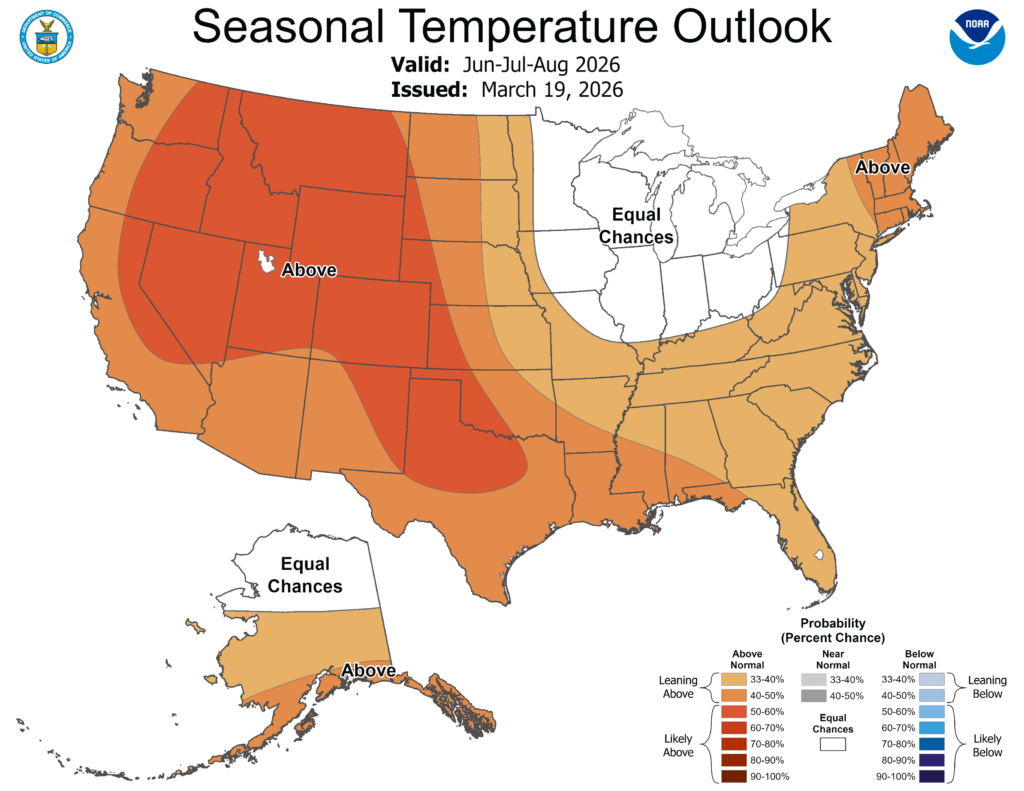
But what about our forthcoming summer? Temperatures running about six degrees above normal for March 2026 do not give me the warm and fuzzies about what is to come. I would note that NOAA’s recently updated outlook predicted above normal temperatures for this summer, but not abnormally so.

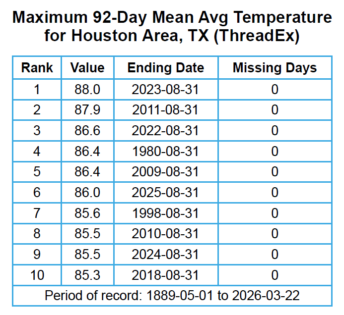
In reality I expect we will see one of our warmest summer ever. My basis for this prediction is pretty simple. Based on average temperature (which is, simply, a daytime high and low temperature, divided by two) the last four summers have all ranked among the 10 warmest summers on record in Houston. The torrid summer of 2023 set the mark, at 88.0 degrees, but last summer was not far behind, ranking sixth overall at 86.0 degrees.

Monday

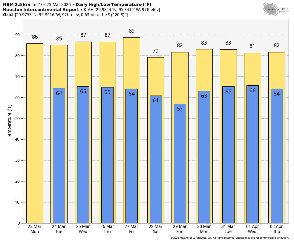
If you’re out hunting for meteorites to the northwest of Harris County today (NASA has a detailed map of where to look) you can expect fine weather to do so. We will see mostly cloudy skies this morning give way to more sunny conditions, with highs likely reaching the mid-80s for most locations. Winds this afternoon will reach about 10 mph, with gusts up to 15 mph. With dewpoints around 60 degrees it’s modestly humid, but not oppressively so. I have been finding recent evenings to be quite pleasant outside. Low temperatures tonight will fall into the mid-60s for most parts of the area, a little warmer near the coast and a little cooler further inland.

Tuesday, Wednesday, Thursday, and Friday

There will be a little variation for the rest of the week. Some days (Tuesday, perhaps) may have a few more clouds. But for the most part these will be mostly sunny days with highs in the vicinity of the mid- to upper-80s, modest humidity, and lows in the mid-60s. It will feel more like early May than late March, but that’s not to say it won’t be fairly nice outside. Rain chances are basically nil, but I wouldn’t entirely rule out a sprinkle on Tuesday. Fog is also likely to return during the overnight and early morning hours.

Saturday and Sunday

A weak front will likely push into the Houston metro area on Friday night or Saturday morning. This is unlikely to bring any precipitation with it (more on that in a moment) but it should usher in some slightly cooler weather. Look for highs this weekend to likely top out in the 70s, with lows perhaps in the 50s. Regardless, skies should remain mostly sunny. If you’re planning to attend the Houston Open golf tournament this week and weekend you really have no weather concerns aside from warmer-than-normal temperatures on Thursday and Friday, and the need for sunscreen on all four days.

Next week

Next week does begin to look a little more promising for rainfall. Obviously we’re days and days away, but most of our model guidance points to increasing rain chances by Tuesday or Wednesday of next week. So it’s something we’ll monitor, but not about which I’m prepared to make any promises yet.

2 Likes

I like counting, so I thought I’d put out some temperature numbers from 2015-2016, which was the previous two years where there was a strong El-Nino cycle. Data retrieved from Climate

Normal average temperature 1991-2020 Average temperature 2015 Average temperature 2016
April 70 72.5 69
May 77.4 77 74.5
June 83 82.2 82.1
July 85.1 86.1 87.1
August 85.2 85 84.6
September 80.5 79.9 82.7

What did I learn from this? I guess that some months it was colder than ‘normal’ and some months hotter than normal. This temperature data is from 11 years ago, and I’d guess global warming may have more effect now than 11 years ago.

In my opinion we tend to expect specific weather impacts from nino/nina cycles, but there are a lot of things that affect weather beyond el nino. In other words, we might expect super hot or dry weather, but those expectations might be broken by other forces.

1 Like

I’ve read elsewhere that a strong El Niño would decrease hurricanes chances this summer, is that correct?

2 Likes

I pulled this image from El Niño and hurricane season: What it means and how it plays out | Fox Weather

Meteorologists say that yes, el nino reduces hurricane activity. But guess what? A hurricane can still develop. And if it does then some warm water over the pacific and a little bit of wind shear might not stop it.

2 Likes

Mr.Berger, couldn’t you just lie to us even a little bit?

Back to reality. Eric is using current conditions including a persistent drought to come up with pizza oven summer again.

I’m interested to see if the sub tropical jet can get things going in terms of chipping away at the drought in April & May. If we can get a wet spring going, we can preempt a possible dry summer, 2002, 2006,& 2008 was like that. Dry spring up until May, and it was daily rains for much of the summer.

2 Likes

2025 did not seem that hot to me, I guess because I rarely pay attention to or even notice the low temperatures during summer, whether it’s 74 or 80 degrees…as opposed to 94 vs 100 in day time. I’d be more about curious about your predictions based solely on peak high temperatures.

1 Like

Does El Niño at least mean more rain this summer/next summer?

with el nino / la nina, people often focus on temperature, but based on my experience its more about the precipitation. Any effect on temperature is probably secondary. See below partial clip from AI for southern states - note the cooler temps in winter are probably due to cloud-cover from rainy cycles:

Temperature and Precipitation Changes

General Effects

  • Southern U.S.:

    • Typically experiences above-average precipitation.

    • Cooler temperatures are common during winter months.

1 Like

a strong el nino should mean we also have somewhat of a fall and winter? Winter should range from normal to slightly cooler than usual?

1 Like

Man, we need some rain soon. I hope the prediction next week holds up. Having to break out the sprinkler in March is awful.

1 Like

Especially when SSTs overall are much warmer than they used to be. All it takes is one under the right atmospheric conditions to be a monster.

Historically yes, but having higher rainfall is even more likely than below average temperatures with El Nino. Especially since the background effects of the warming world has been preventing us from having any prolonged cool periods for a long time now.

However, If I were to take a gamble, I would bet on the fall of 2026 will probably be more cloudy, rainy, cooler and more fall like than the previous two.

1 Like

Since reliable ENSO records started in 1950, there have been ZERO hurricane landfalls in Texas during an El Niño season (there have been 6 tropical storm landfalls, however). The only one that got close was Hurricane Audrey in 1957 which made landfall in far SW Louisiana. This is likely because of not only the more unfavorable Atlantic conditions, but because El Niño also favors a weaker Bermuda high which increases the likelihood of storms tracking in the Eastern Gulf or turning out to sea. I’m not saying we won’t see a hurricane this season (there’s a first time for everything), but climatology tells us that’s very hard to do in Texas during El Niño.

3 Likes

Neither really. The ENSO doesn’t have any direct correlation to what weather we will have during the summer. It can go either way. The affects of La Nina/El Nino come into play during the fall, winter, and spring because of how they manipulate the polar and tropical jet stream. During the summer both jet streams tend to track far north of Texas regardless of the ENSO.

However, La Nina can increase our chances of having a rainy summer because of increased tropical activity, but it is still a coin toss.

@Josh It certainly is. I had to get a new sprinkler because a lizard crawled into the one I had, couldn’t get back out, died and clogged it up.

I really enjoy cold AND sunny. Which here, is almost impossible. Through our living experiences, if houston is cold or abnormally cold, it is almost always a grey, dreary, rainy day.

1 Like

You don’t have to ask if summer will be bad. It will be downright nasty.

Yeah, asking if the summer in Houston will be bad is litterally equivalent to asking if next winter in Duluth Minnesota is going to suck.

This topic was automatically closed after 24 hours. New replies are no longer allowed.