Tonight is likely to be the coldest night for the next six months

Originally published at: Tonight is likely to be the coldest night for the next six months – Space City Weather

In brief: Houston is continuing to experience cooler conditions in the wake of a front, and indeed temperatures tonight are likely to be the coldest the region experiences for the next six months. Some rain chances return later this week, but I’m hopeful they won’t be too impactful for the weekend.

Cool interlude

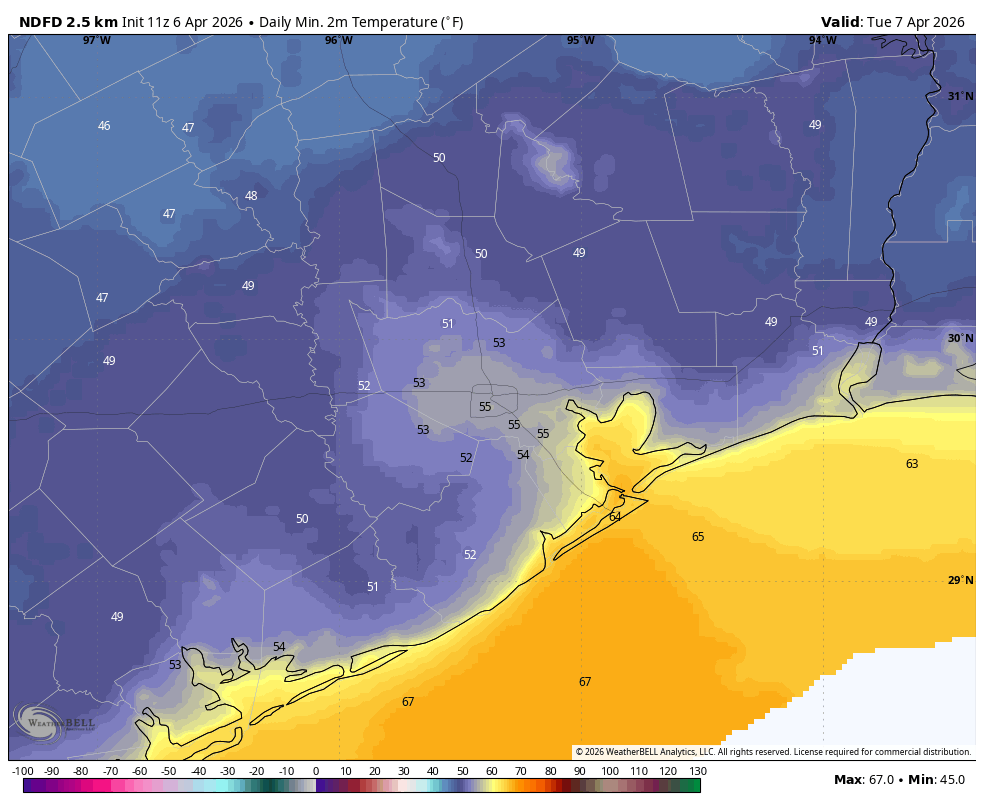
We are continuing to see a cool, northerly flow this morning and our pleasantly dry air will persist for about two more days. Tonight will be the coldest night of the forecast period, with low temperatures dropping into the 50 to 55 degree range for much of the metro area (except for the immediate coast), with some inland locations probably dropping into the upper 40s. Based on an expected warmer spell through the middle of April, I therefore expect this to be the coldest night not only of April, but probably for the next six months. Historically, we often don’t drop into the mid-50s, or lower, until at least mid-October. So open the windows and enjoy the ahhh that’s coming with this interlude of cooler and drier air.

Monday

Today is going to be a lovely day. Our skies will start out cloudy but should begin to clear out this morning before becoming mostly sunny this afternoon. Highs will reach the mid-70s for most locations, with a moderate northerly wind. With clear skies and light winds, conditions will be ideal for radiational cooling. This will allow temperatures to fall nicely tonight, with some exceptionally crisp air likely north and west of Houston. Also, a quick space update here: The Artemis II astronauts are flying around the Moon this afternoon! NASA will cover this live here.

Tuesday

Winds will shift to come from the east on Tuesday, but this will still be a fine, sunny day with highs likely in the upper 70s. As the moisture levels in the air creep up a little bit, our overnight low temperatures will be a few degrees warmer, likely only falling to about 60 degrees in Houston, with slightly cooler conditions for inland areas.

Wednesday, Thursday, and Friday

Our temperatures will continue to inch upward this week, with highs likely around 80 degrees, and overnight lows rising from the mid-60s on Wednesday night to around 70 degrees by Friday night. Each of these days should see a fair bit of humidity, along with a mix of sunshine and clouds. Each day will also have a chance of showers, with Friday appearing to have the best odds at this point (perhaps 40 or 50 percent area-wide) due to a passing upper-level disturbance. In terms of accumulations it’s too early to say too much, but we probably are talking tenths of an inch of rain rather than actual inches. We’ll see.

Saturday and Sunday

There’s a lot going on this weekend, including the Art Car Parade on Saturday. At this time I expect lower rain chances for Saturday and Sunday (perhaps 30 percent?) along with partly sunny skies. So a passing shower is possible, but right now I don’t think sustained rainfall is likely. Temperatures should be a bit warmer, with highs in the lower 80s and fairly humid air. Overnight lows this weekend may only drop to around 70 degrees. The bottom line is that this weekend should be mostly fine for outdoor activities, but I want to wait a day or two before having full confidence in the forecast.

Next week

Most of next week should have temperatures in the low 80s with fairly humid air as well. Things are a bit fuzzy, but at this point I expect a couple of more chances for showers next week, so hopefully we can continue to put a dent into our area’s drought conditions.

3 Likes

Sadly only I only picked up a quarter of an inch of rain in my raingauge this weekend. So, hopefully we get some more next week. :crossed_fingers::crossed_fingers:

1 Like

The rains, they never really came. The drought continues deeper as summer approaches

Our area of Copperfield got 0.71”. Yay!

1 Like

The Gulfgate Shopping Center area received about 0.49 inches of rain this weekend. The normal low for today is 57° Fahrenheit.

The climate is warming so fast that the previous 30-year averages have become practically meaningless at this point. The baselines are shifting upwards by the year it seems.

Houston has only recorded 22 months below the 30 year norm since 2020. 22 out of 75. That means we are 3.5 times more likely to have above normal temperatures any given month based off the past 6 years of data. And the last month to average below normal in Houston was January 2025, 14 months ago if that says anything about the current trend we are on.

Intuitively I know that the temps have been bumping up over the past several years, but I appreciate your putting the phenomenon into a numerical context.

1 Like

I agree. The world is getting warmer, and Houston will feel the effects of it.

I’m genuinely curious how climate change will specifically affect Houston. Will the summers continue to be 98 deg F high and 80 deg F low? Will the high temperature get higher? Will the low temperature get higher? Will electricity continue to be cheap and available? Will fall, winter, and spring continue to be pleasant? Will people stop living here because of the climate? Will my house lose value because it is located in a hot climate? Will hurricanes become more or less frequent? Will storms get more or less intense? Will droughts get more or less frequent?

I don’t know the answer to most of those questions. I know for certain that temperature will be higher across all seasons, and especially in the fall, winter, and spring. I know that summertime high temperatures are moderated by the gulf water, but by how much? I know that the gulf is warmer, but how much does that increase the probability of hurricanes?

I have a feeling that moving somewhere else will be better for my future long term.

Got 0.86” over the weekend in east Katy (0.83” Saturday, 0.03” Sunday). Not bad!

Previously I only recorded 4 days with more than 0.01” since the end of January.

Those are all great questions that I ask myself repeatedly all the time. Honestly there is no way to know 100% exactly the effects the warming climate will have in Houston or globally in the distant future. However, it is clear that in our region of southeast Texas, it has gotten hotter, more humid, and less cool overall over the past 10 years. I think we will continue to have summers with higher highs and higher lows, but we will still have variations, with some summers being more wet and cool than others. We will still have periods of cool to cold weather during the fall and winter, but overall, our winters will likely continue to be warm much more often than cold.

Precipitation is still a coin toss because of other factors. However, a warmer climate can increase rainfall extremes by increased evaporation from the Gulf, adding more water into the atmosphere to fall as rain. The mixture of a wetter atmosphere and increased urban sprawl, will exacerbate flooding events, like Harvey for example. On the other hand, droughts are more likely to occur and be more severe because hotter temperatures evaporate soil moisture even quicker. Basically, our already natural big swing between extreme rainfall and drought will become even wider. Hurricanes will absolutely get worse and happen more frequently, increasing our chances of getting hit by a major one.

at the end of the day, it is clear that extremes of all varieties are happening more often and getting more extreme overtime. Basically, our climate has always been extreme to a certain degree but it is on steroids now. This may not be true but there are predictions that by 2050, the southern United States could see heat indexes of 125 and above regularly during the summer months. Idk about you but that is not an environment I want to live in. So, it is very likely that millions of people will eventually start fleeing the south into northern regions in the coming decades.

Indeed!! I’ve been calling these “averages” lagging (they are now 20 years behind) and irrelevant. The crazy thing is outside of January, the last below average temp month was Nov 2023!! Since then only Jan 2024 and Jan 2025 have been below average! I got 1.3 inches of rain on Caturday but it just fits with the usual pattern of 1 hour of rain every 3 weeks. At least it has been truely cloudy in thsi pattern but I am so fatigued of this heat. The cooler weather yesterday and today has felt more normal than anything in thsi recent Marchugust. Sadly we have Torchpril, Torchay, Torchune, Torchuly, Torchugust, and Torchtember to make it through. :hot_face: :hot_pepper: :sun: And plz hopefully not Torchtober and El Niño can kick in!! Hey one positive about thsi lame pattern is I got to learn a lot of new names for the months,yayy expanded vocabulary!!! :melting_face::melting_face::melting_face:

2 Likes

Got a lot of rain north of Houston this weekend. Enjoyed the outdoors yesterday, pretty much perfect weather to me.

Really didn’t get much in League City :frowning: It was absolutely better than nothing, and I’ll take it, but man, we could use a nice multi-hour soak.

1 Like

Please remember that our earth is an estimated 4.5 billion year old planet that has been through several stages of ice ages, hot house climates, and extinction events. Even before the first known fossils of homo erectus. While I agree we have not done much to improve our climate, we really only have data from roughly 1885ish to today. Small percentage in the big picture.

I was pleasantly surprised to find that my rainfall prediction was wrong: we got 0.93 inches at my house!

Average highs in July and August today (average of the past 10 years at IAH) are 95 and 96 degrees, respectively. I would guess that they will increase by something like a degree every decade or two. So I would guess that the averages by 2050 will be around 98. Now, I may be wrong, but I would also guess that humidity would go up a similar amount due to the Gulf warming. So I’d expect the heat index to go up at least twice as much as the temps by 2050.

I’ve been thinking about this a lot because I am determined to stay here and I expect to work outdoors. On the other hand, I suppose if people do start fleeing north, land will get cheaper, and maybe I’ll be able to afford some. We certainly haven’t started seeing that yet though.

Only 0.60” here for the whole weekend - another rain forecast bust.

Goodbye, cool, comfortable mornings….come back ASAP!

I’m not intending to stay long enough to find out. Especially with us getting hit by a hurricane or tropical storm every 2-3 years now.

2024 Beryl (now wasn’t that a lot of fun for a Cat 1)

2021 Nicholas (put a tornado in my subdivision)

2019 Imelda

2017 Harvey (not putting myself through another night of terror like that)

This topic was automatically closed after 24 hours. New replies are no longer allowed.