Houston will end a frying February with an exclamation point

Originally published at: Houston will end a frying February with an exclamation point – Space City Weather

In brief: In today’s post we’re celebrating like it’s the 80s all over again, because that’s how February is going to end. In fact, with three days to go, this month already has had the third-warmest days on record in Houston. A weak front will bring somewhat drier air into Houston for the weekend.

Frying in February

On average, February is the third coolest month of the year in Houston. Put another way, of the winter months, it is the warmest; but still significantly cooler than the rest of the year. The normal high temperature for the month, based upon temperatures from 1990 to 2020, is 67.9 degrees. This year, our average high temperature with three days to go is 74.2 degrees. (Only 1962 at 74.4 degrees, and 2017 at 76.8 degrees rank higher).

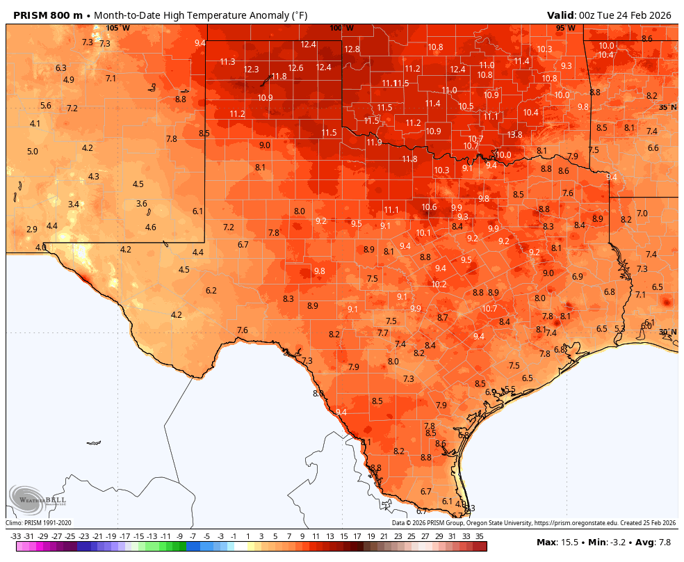
It’s not just been Houston. Persistent high pressure for much of this month has kept the entire state of Texas and our neighbors much warmer than average (see map above). Highs in the Panhandle and parts of Oklahoma have been especially hot, relative to normal temperatures this time of year. As we’ll report below, the heat party we’ve been dancing to this month will turn into a rave today as high temperatures soar as much as 20 degrees above normal. In fact we probably will end February with four straight days of highs of 80 degrees or above.

Thursday

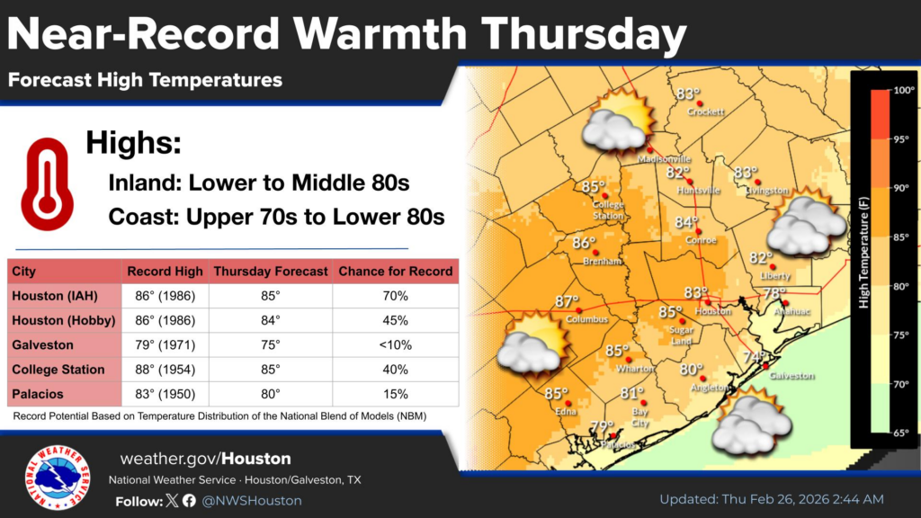
Our winds have settled down some this morning, but they’re still a bit blowy from the southwest. We could see gusts up to 20 mph, but that will feel like nothing after widespread gusts of 40 mph on Wednesday. Because skies will be a little more cloudy today, I think that may shave 1 or 2 degrees off our previously forecast highs, and that could keep most of our locations at or below record high temperatures this afternoon. It’s still going to be warm, however, with highs in the low- to mid-80s for most locations except for the immediate coast. A weak front will arrive late tonight, but not in enough time to do much with lows, so expect them in the range of 65 degrees for most locations.

Friday

This will be a sunny day, and lower dewpoints should allow temperatures to push into the low- to mid-80s again. However, with the drier air it should feel somewhat less humid (the further inland you are, the less humid it will be), and low temperatures on Friday night should drop down to around 60 degrees. Note this is still pretty warm for this time of year, as the front just is not going to bring all that much oomph along with it in terms of colder air.

Saturday and Sunday

These should be partly to mostly sunny days, with high temperatures around 80 degrees. Yes, there will be some humidity, but no, it will be very far from oppressive by Houston standards. Saturday night should see temperatures drop down to near 60 degrees again, but Sunday night will be warmer. Saturday’s winds look moderate, but by Sunday afternoon we might see some southerly gusts up to around 20 mph.

Next week

Not much changes through at least the middle of next week. We’re going to see partly sunny days with highs in the vicinity of 80 degrees, and lows in the lower- to mid-60s. Some slight rain chances may return by the middle of the week, but we may have to wait until the weekend for a real uptick in the precipitation outlook. But this is far enough into the future that our forecast turns pretty fuzzy, pretty quickly.

I hope everyone has a terrific Thursday!

3 Likes

This warm weather is UNUSUAL (or maybe it is just the new usual)! I must say I felt very comfortable outside for most of February, but I hope the warm weather doesn’t persist in June-August. Could you imagine persistent +6 deg F above normal high temperature? That would put our high temperature in June-August about 95+6=101 deg F. If the low temperature was also +6 above normal it would put our average low temperature at 75+6=81 deg F.

GET READY TO GET SWEATY!

1 Like

Is it ever going to rain again?

I thought Houston was supposed to be a rainy climate. :sob:

1 Like

It generally is but our region lies close enough to the desert southwest that oftentimes the dry, warm air from the desert wins the battle ahead of the cold fronts, curtting off the convection needed for storm development.

It depends on the wind patterns ahead of each cold front. If the winds are blowing in a southwesterly direction ahead of the cold front, than warm, dry air from the desert mountains of Mexico will drift over our region and prevent the warm, humid air at the surface from rising high enough to cool and condense into to rain drops.

When the winds are blowing directly from the Gulf into the approaching cold front, that is when we have the best chance at seeing widepread soaking storms blossom in our region. Without getting into to much details, the northward jet stream track influenced by La Nina increases the chances of this dry desert cap over our atmosphere during the fall, winter, and spring. And that is exactly what we have been seeing.

i know i sound like old man yells at cloud but the last 365 days have to be some of the worst weather you could have in the US.

I probably ended up having my AC on in my house 330 of the last 365 days.

4 Likes

You can tell from that the contours of the first image from 2011, that the wind was blowing generally out of the southwest ahead of the cold front. We got little to no rain from that front.

The 2nd image is the surface map from one day before the Tax Day Flood in Houston. Notice the difference in the wind direction ahead of that front?

2 Likes

There’s been below average rainfall every month since August.

Pretty accurate for us up in the Atascocita area as well. AC getting used too much (and we’re far from keeping a chilly house), leading to increased electricity bill and decreased service life of the unit, which will cost down the road.

2 Likes

how many years have to pass to adjust what is considered “normal” temperatures? If the normal high in february is 68, how long until the normal high in february is 80?

1 Like

The climatological normals are based on 30 year averages updated every 10 years. We are currently using the 1991-2020 base period. The next update will be in 2031, which will use the 2001-2030 period.

3 Likes

You can notice changes in average highs and lows in just a few years. However 30 years tends to be the standard used when considering average temperatures or rainfall for any given month. It is also updated every ten years. 30 years makes it easier to even out the drastic variations that can occur year to year and makes long-term trends easier to see.

It would take many years of exceptionally warm February’s with highs in the 80s most days for the “average” highs to reach 80 degrees and above in Houston. Even with our current rate of warming, it is still quite a longshot from February ever being that warm on such a consistent basis. However, it could happen eventually, but it would be a very long time from now especially if measures to significantly cut back greenhouse gas emmisions are not taken in the future.

1 Like

@rflores23 Not to mention several days of running the heat in the morning to knock off the chill and then flipping it back to cool for the afternoon.

1 Like

@analogkid84 I feel your pain. I remember when I was growing up in southwest Virginia in the 1960’s and 1970’s (different climate) the old adage of keep your thermostat at 68°F in the summer and 72°F in the winter. We keep our thermostat at 74°F in the summer, which I don’t “think” is too low, but it’s exactly like you said for me as well.

We keep the heat around 67 and the AC around 77. Even our house, which is not very well insulated, hardly ever changes that much in one day. So there’s never really a need to switch it back and forth from heat to AC every day. Thus we can use it much less (in the winter). I wish everyone did that; that way Houston would be using much less energy and fossil fuels.

1 Like

Hey Joseph these old maps are pretty cool. More of these. You forgot to tell them that the wind flows roughly parallel to the isobars towards the low pressure system (the curved brown lines) …nice illustration tho. Nobody seems to get why these repeated La Nina’s do not favor our Gulf Coast with RAIN. Even Fla is on fire!

The Niño

This topic was automatically closed after 24 hours. New replies are no longer allowed.