Originally published at: This year is now half over, what do you remember most about the weather so far in 2026? – Space City Weather
In brief: In today’s post we look back at the first six months of the year, and review the most impactful weather event during that time. We also talk about some increased rain chances for Thursday, and a hot and sunny holiday weekend.
Six months into 2026
As of this morning, this year is now half over. In terms of weather it has been a fairly unspectacular start to 2026 in the greater Houston region, but given the extremes possible here, boring is usually good. The most notable event this year was an Arctic front in January, which followed a very warm start to the year (remember when five of the first nine days of the new year reached 80 degrees, or higher?)
The Arctic front brought widespread low temperatures in the 20 to 25 degree range, and the forecast was complicated by a large amount of precipitation falling just as it moved into the region. Ultimately Houston escaped the worst of this freezing rain. While other parts of the state such as Dallas and Austin were iced and snowed in for days, our region was relatively unimpacted in terms of mobility.
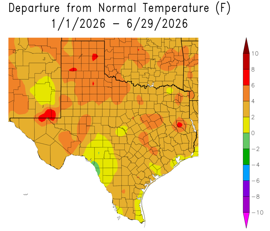
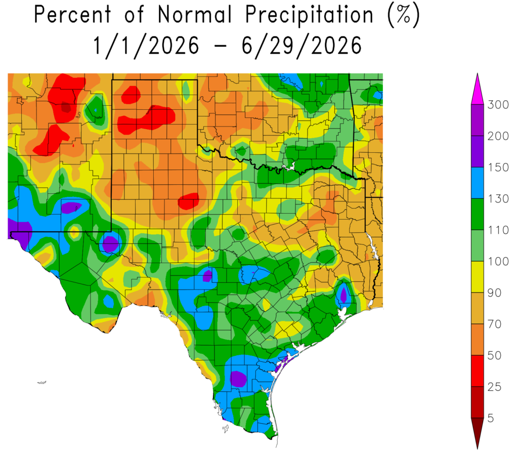
Overall with regard to temperatures, this year has seen above normal conditions on average. The greater Houston region has generally recorded an average temperature of 1 to 4 degrees above normal. With regard to precipitation, a wet end to spring and start of summer helped pull the region out of a drought. Although parts of Montgomery County remain below normal for this year, most of the Houston region has received 100 to 130 percent of normal rainfall levels. Some parts of Chambers County have received nearly twice as much as normal.
What will the second half of the year bring? It’s always a mixed bag in Houston. We get our hottest temperatures of the year from mid-July into early September, and our best chances for hurricane disasters. But then, if we can get past that period, fall beckons and that is a great time of year for our region. So as ever, with our weather, we will have to see what happens.
Wednesday
This day will see a continuation of our recent weather pattern, with high temperatures generally in the low- to mid-90s across the region, along with mostly sunny skies. Like we saw on Tuesday, there will probably be some isolated showers and possibly thunderstorms dotted across the region this afternoon. But your overall rain chances are probably on the order of 20 percent, and in most cases the showers should pass quickly. Humidity remains high (of course!) and lows tonight will likely fall into the upper 70s.
Thursday
We’ll see a little more atmospheric moisture on Thursday, and with high pressure now having moved away to the northeast, I think there will be a slightly better chance of rain, probably something like 30 to 50 percent for the Houston area. Of course any showers will be hit or miss, with some locations getting no rainfall at all, and perhaps a few isolated areas seeing as much as 1 inch. Highs should still reach the low- to mid-90s.
Fourth of July holiday weekend
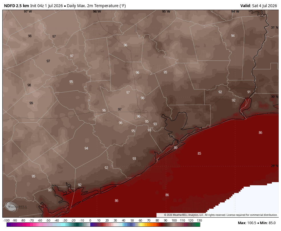
For the most part sunshine and heat will prevail this weekend. Expect daily highs in the mid- to possibly upper-90s for most of Houston, with only coastal areas remaining a few degrees cooler. Winds will also be fairly light. We’ll see something like 10 percent rain chances on Friday and Saturday, and possibly up to 20 percent on Sunday. So again, overall odds are low, but we cannot rule out some passing showers during the afternoon hours. Conditions for fireworks look ideal, if hot.
Next week
It is difficult to say too much with confidence about our weather next week, but we may enter a pattern in which we see a few more clouds during the afternoon hours. This may shave a degree or two off of high temperatures and introduce some slightly better rain chances to start the week. Whether this weather lasts all week is something we’ll have to see about.

 However, I’m glad we were able to get the Arctic blast without any serious complications involved. We also had another strong cold front which dropped our morning lows into the mid 20s on February 1st. Than spring soon set in.

