August is over. So how did this summer stack up? The answer may surprise you

Originally published at: August is over. So how did this summer stack up? The answer may surprise you. – Space City Weather

In brief: Today’s post reviews the summer of 2025 in Houston. Some residents may believe this one felt cooler than is typical. We see what the data says about that. Additionally, we look ahead to this week’s weather in the wake of a front that finally pushed through over the weekend.

A review of summer 2025

August has come to an end. For most of us, in terms of weather at least, that is cause for celebration. Not because the kids are back in school, and teachers back at work. Not because summer vacation is over. But rather, because August is the hottest and most severe month for weather in Houston, and cooler conditions are on the horizon. September 1 also marks the start of meteorological fall, so it allows us to step back and ask, how hot was this summer?

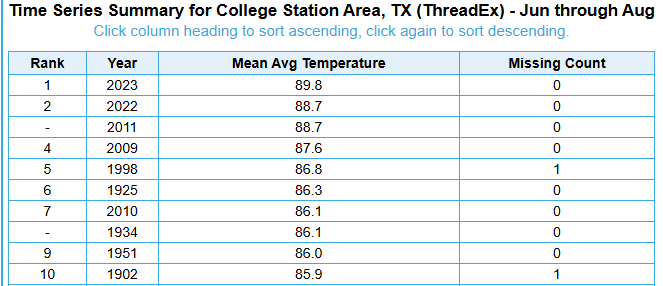
My immediate reaction is that this summer felt fairly mild. There were no prolonged periods of high pressure and blazingly hot days. However, when we dig a little deeper, we find a different answer. Matt already wrote about this in one of our monthly Q&A’s, but this summer has been sneakily hot. When we look at the “average” temperature for June, July, and August of this year, we get a value of 86.0 degrees. This is simply the daily high, and daily low, divided by two for the last three months. It turns out this summer was the sixth hottest June, July, and August in nearly 150 years of Houston temperature records.

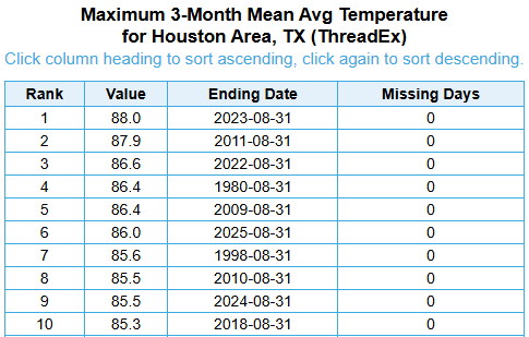
You might say, well, it did not feel that hot. And you’re right, the days were not blistering hot. In terms of daily highs, our average of 94.9 degrees only ranked 12th on record in Houston. My sense is that summer days felt cooler because a) we had more clouds and periodic rainfall to help cool days off, and b) recent summers such as 2022 and 2023 were so incredibly hot that they have reset our expectations of normal. Where this summer was exceptionally hot, however, was at night, when the daily minimum temperature averaged 77.0 degrees. This is tied for second, all time, behind only 2023 (77.4 degrees).

So what’s going on here? Well, it’s complicated. Certainly the urban heat island effect (widespread sprawl and concrete, which absorbs more heat) is playing a role. But Galveston and College Station also recorded summers that ranked in the top 10, in terms of overall heat. So there is more happening in the background here. The main driver of our warmer nights is the Gulf, which greatly influences our nighttime temperatures. This is due in no small part to warmer oceanic temperatures around the planet. Our world is heating up, and in Houston we are experiencing that even during a “mild” summer.

Tuesday

Following widespread rainfall over the holiday weekend, showers this morning are mostly offshore after a weak front has moved into the area. I think we’ll still see a slight chance of rain later this morning (30 percent, maybe) for areas along and south of Interstate 10, but the trend is clear. We are going to see an influx of moderately drier air over the next couple of days. Skies today should be mostly sunny, with high temperatures in the vicinity of 90 degrees. Low temperatures tonight will drop into the mid-70s in the city, with slightly cooler temperatures possible for inland areas.

Wednesday, Thursday, and Friday

These will be the driest days, which in early September means there still will be some humidity. Still, it should feel a little bit drier outside, with highs likely reaching the lower 90s in Houston, and mid-90s for some inland areas. Skies will be sunny, with virtually no chance of rain. I think Wednesday night into Thursday morning will see the “coolest” weather, with some inland locations potentially hitting the upper 60s. Obviously this is not cold, but the nights and mornings should feel a little bit more mild.

Saturday, Sunday, and beyond

Some time on Friday, probably, the pattern will change as the onshore flow returns. This will raise humidity levels and should give us a warmer night on Friday, and start to increase rain chances this weekend. At the same time another front will approach our area from the north. It is not entirely clear whether this front will push down into Houston and off the coast, or stall. But the bottom line is that we probably will go from highs in the low 90s on Saturday to the upper 80s on Sunday and Monday, with a decent chance (maybe 30 percent) of showers on Saturday and better chances on Sunday into early next week. I don’t think we’ll see a repeat of the heavy rains we experienced over Labor Day weekend, but I cannot be sure of that. Most of next week should see highs in the vicinity of 90 degrees.

1 Like

If you just look at IAH yes our summer was hotter weighing in at 1.7 F above normal. But if you dig deeper and look at the sites from around the area it tells a slightly different story and why so many people have a different view of this summer.

I looked at the data from 16 of the official NWS stations and I took the average from June, July and August and compared it to the normal for that time. IAH came in hottest at +1.6 degrees above normal. El Campo was the coolest at -.74. The average of all 16 official recording stations(that had data) was +.45 above normal.

So if you only look at IAH we were hot. If you look at the rest of the surrounding area, not so hot. El Campo, College Station and Crockett were actually below average this summer.

Which brings up the question why is IAH so much warmer than the surrounding areas?

1 Like

More concrete than vegetation. Same for the inner city.

2 Likes

I think another way to measure summer is dew points. We rarely had any oppressive dew point temperatures which explains why Houston was never under a heat advisory for the entire summer. When was the last time this happened.

1 Like

Someone must be wrong here. Eric said College Station had a “top ten” hottest summer. Glenn said College Station was cooler than normal. Could someone please explain?

Great point Glenn. I would like to add that places like College Station are urban heat islands as well. There is concrete being poured other places than Houston.

When I go to the NWS site College Station was -1.1 in August, -.9 in July and +1.8 in June.

“College Station Area” on the NWS website. Not sure if they have more than one site which is possible

Eric,

Thanks for this analysis and perspective.

I may have missed this, but have you also compared/analyzed triple digit days? Would love to see how that looked year on year , and wondering if he have had fewer of those days so far this summer and thats why it feels a bit milder this year. (Hope not jinxing it).

1 Like

I don’t want to get Eric upset with me. I’m not sure if we are using the same data sets. For example I could be using the data from 2000-2025. He could be using data from 1900-2025. I’m not sure.

No one will be upset w you, Glenn. You’re a sweetie :penguin:

1 Like

Is it too early to look at long term forecasts (maybe 14-21 days?) to see if any strong cold fronts are on the horizon?

IAH was the “only” official climate site that recorded 100 degree days this summer. I believe they had 7. The urban heat island or how close the weather station is to the runway has to be the difference.

1 Like

Did you use the weather.gov climatology page to get data for the other NWS stations? I’ve found that getting historical temperature data can be challenging.

Surely there might be other factors beyond just those two.

You should probably just rank summers by high temperature. Whether it’s 74 at night or 78 really doesn’t matter, my AC is running regardless. Only time I care about the low temperature is when we have cold fronts.

While it’s great that everyone is tossing around averages (which I wish people would state whether they are using mean/median/mode), I think it would be just as, if not more useful, to also include standard deviations relative to historical record for a site, as well as for the past 20-30 years. IOW, is a +1.5 or a -0.8 degree change significant. Averages, whichever you choose to use, are great but they fail to tell the whole story.

1 Like

Yes I used the weather.gov page. Then clicked on NWS Forecast Office Houston/Galveston. Then Climate and past weather. Then clicked on Nowdata NOAA online weather data. A list of NWS area sites is available with sites ranging from Houston area to Wharton. A handful of them do not have recorded data but about 16 of them do so I used the averages from those stations.

1 Like

Once again I don’t want to step on any toes or hijack the thread and make anyone at SCW unhappy with me. When I checked out the data on the NWS I just seemed to notice a difference between the “average” of many of the other recording stations and what was going on at IAH. I did not do a peer reviewed study of average/mean/median or standard deviation from station to station. The difference was big enough to make me a little skeptical of the data at IAH. I suspect, and it’s only a suspicion or a hunch that there is something wrong with the station at IAH. Maybe it’s not calibrated correctly, I think they did send a technician out there to check it out in July. Maybe it’s some other reason. I don’t know but it seems the discrepancy between the temps at IAH and elsewhere in the area is due to more than just chance…

3 Likes

@Glenn Seems to me that all reporting stations should be on the same page and calculating averages the same way. A discrepancy would make me wonder too.

Here’s the data straight from NOAA.