Originally published at: They said we were crazy to forecast Thanksgiving weather two weeks out. They were probably right. – Space City Weather
In brief: In today’s forecast we talk about our warm weather across the next week, and when it should start to rain again. We also venture into the perilous mists of long-term forecasting, and issue a preliminary prognostication for Thanksgiving Day in Houston.
Thanksgiving forecast note
Yes, at the end of today’s post we are going to take a stab at forecasting the weather for Thanksgiving this year, which is a full two weeks from today. It’s a little mad to try and do this because, as a general rule, forecasts are usually pretty accurate out to five days, and have some value from five to 10 days out. And after 10 days, well, sometimes forecasters can be a little more accurate than throwing a dart at a wall. Sometimes. We’re going to take our best shot anyway.
The reality is that, because we own and operate Space City Weather independently, Matt and I have complete editorial control. We don’t work for anyone but our readers—that’s you. So we can do zany things, and take chances, and have some fun. That’s why our annual fundraiser is so important. If you can support us, please do. If you can’t that’s totally fine as well. We understand this economy isn’t helping everyone.
Wednesday
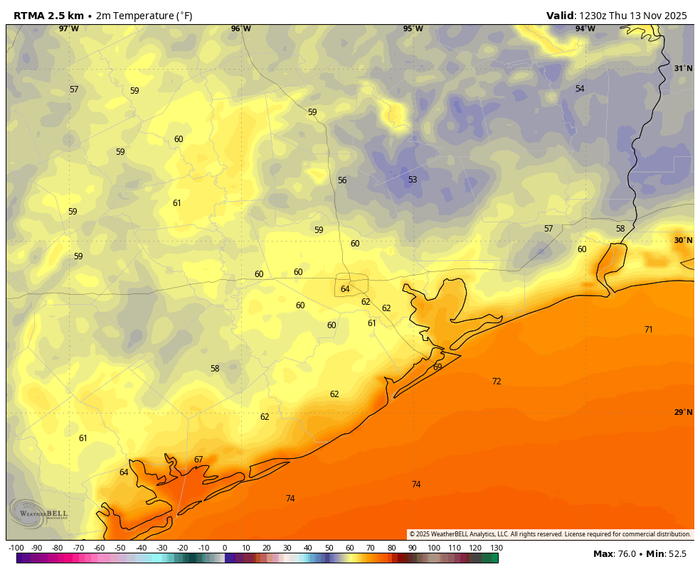
Lows across most of the region this morning are in the vicinity of 60 degrees, nearly 10 degrees above normal for mid-November. And still, this will be the region’s coolest morning for the next week. That’s because high pressure has moved in, and will remain more or less in place, allowing for a persistent, warm-ish pattern. Highs today will reach about 80 degrees across the area, or slightly above. Winds will come from the southeast, mostly light, but gusting up to 20 mph during the afternoon. Lows tonight will drop into the mid-60s in Houston, with the potential for some patchy fog to develop.
Thursday and Friday
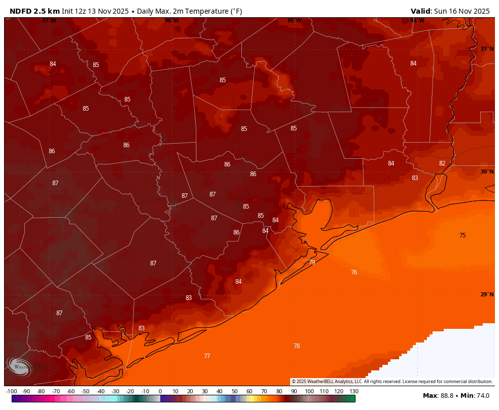
These will be mostly sunny days with highs generally in the low 80s. Nights will be mild, in the mid-60s, with the potential for fog. With dewpoints around 60 degrees it will be somewhat humid, but not excessively so (just you wait, it’s coming). Rain chances remain near zero.
Saturday and Sunday
Sunshine will continue, with highs in the mid-80s (possibly nudging into the upper 80s on Sunday). A front will approach the area, but wash out before moving into the region. Nights should remain in the mid-60s for most. Rain chances will be low, perhaps 10 percent, for each day. Plan your outdoor activities with confidence.
Next week
The first half of next week looks rather warm and humid. We’ll see another boost in atmospheric moisture, and this will nudge the humidity levels up. Monday or Tuesday could see a dewpoint near 70 degrees, which is extremely humid for this time of year. High temperatures will likely be in the vicinity of the mid-80s, with partly cloudy skies. Nights will be warm and mild. This increasing moisture will lead to some low-end rain chances, perhaps 20 to 30 percent on Monday through Wednesday.
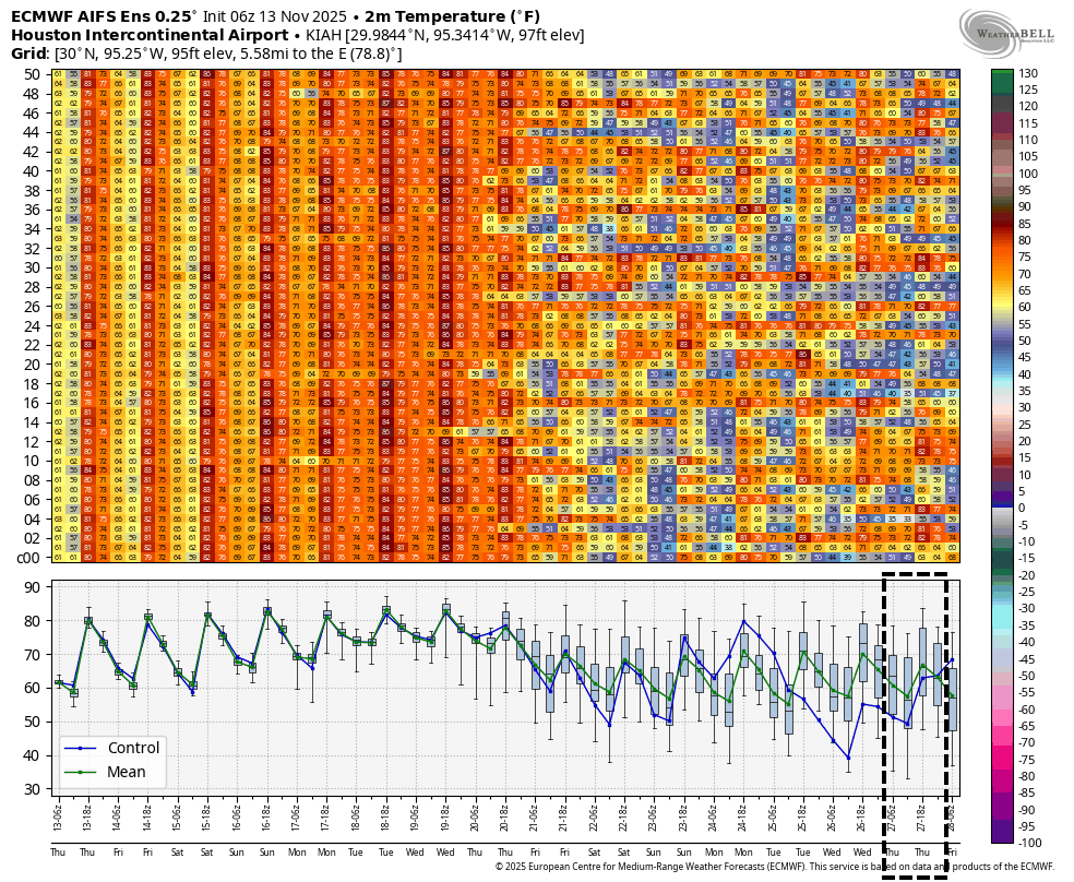
Then, about a week from now, there is general agreement in the models that some sort of front is going to push into the area, bringing better rain chances and cooler air. Since this is about a week out our confidence is lower in the details. But I’m hopeful it will bring an end to the anomalously warm pattern for November, and also some needed rainfall.
Thanksgiving week
So what does the weather look like a full week after that? We are now entering the danger zone for forecasting. With that said, there is a rough signal in most of our best model guidance for a somewhat stronger front to move into the area about 10 days from now, in the vicinity of Sunday, Nov. 23. This would set the stage for a pleasant week, with highs perhaps around 70 degrees and nights in the 50s. My official forecast for Houston on Thanksgiving Day therefore calls for a high of 68 degrees, with partly cloudy skies, and a 30 percent chance of rain. It will be fun to see how wrong this is two weeks from today.
