Cold to end 2025, warm to begin 2026. Also, our first look at Houston Marathon weather

Originally published at: Cold to end 2025, warm to begin 2026. Also, our first look at Houston Marathon weather – Space City Weather

In brief: Houston is quite chilly this morning, and we’re dropping down another notch tonight. But following this we’ll be solidly on a warming trend heading into the new year. This weekend looks quite pleasant. Also, we take a peek at what weather might be like for the Houston Marathon.

Freeze line

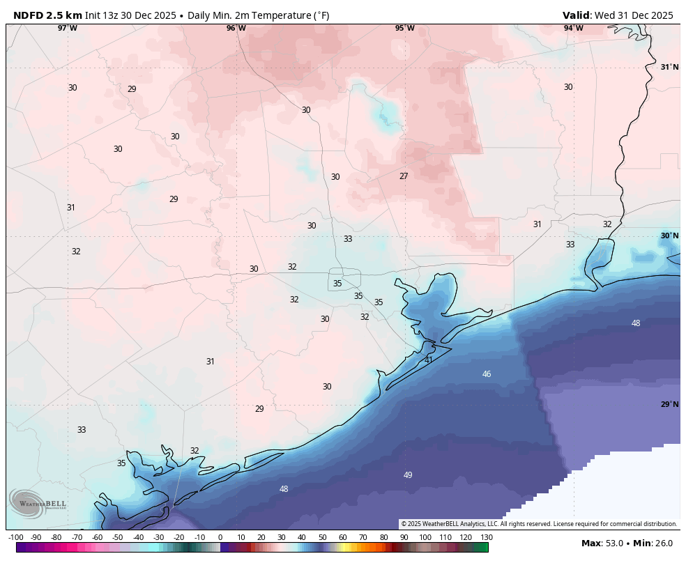
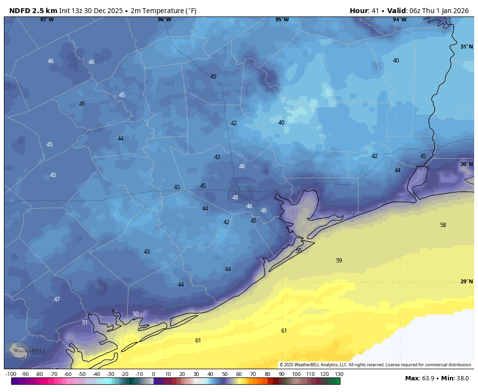
Temperatures are comfortably above freezing this morning across the Houston metro area, but what about tonight? We are going to see ideal conditions for heat to radiate back into space this evening, including clear skies and light winds. This will bring a light freeze into the Houston region. My sense is that urbanized parts of Houston and coastal areas will remain just above 32 degrees, but that inland areas and outlying suburbs, such as Katy, probably will briefly freeze tonight. Essentially, if you experienced freezing conditions back on Dec. 15, there is a decent chance you will again tonight. These temperatures are not cold enough to affect pipes or anything like that, but do take care of sensitive plants and pets.

Tuesday

We are going to see solid sunshine today (and most of the week). This will allow highs to warm into the 50s today, with light northerly winds, before our chilly night tonight.

New Year’s Eve

After a cold start, expect highs in the mid-60s on Wednesday with sunny skies. Light winds will turn west, and then southwest over the course of the day and evening. We have no weather concerns for the New Year’s Eve holiday aside from chilly temperatures during the evening, likely dropping into the 40s by the time we ring in the new year.

New Year’s Day

With a southerly flow in place we’ll see a warmer day to start 2026, with highs in the lower 70s. As moisture levels creep up, we may see a few more clouds in the sky, although I expect plenty of sunshine. Lows on Thursday night will be warmer, perhaps dropping only into the lower 60s.

Friday, Saturday, and Sunday

Friday looks downright warm with highs in the lower 80s and sunshine. The weekend should be a bit cooler (although there is still some uncertainty here) as a modest front pushes down from the northwest. For now let’s go with highs in the 70s and lows in the 50s, with mostly sunny skies. Really, it looks to be like ideal weather for most outdoor activities.

Next week and the Houston Marathon

The first half of next week looks to be rather warm for January, with highs likely in the vicinity of the upper 70s and nights perhaps in the upper 50s. If you’ve been wondering about rain chances, those start to pick up around Wednesday or Thursday. That’s not to say rain is likely, but it does appear to be possible.

If you’re planning to run the Houston Half or Full Marathon, then you’re keenly interested in conditions for Sunday, January 11. I just completed my final long run early on Monday, so my body is (mostly) ready. What about the weather? I’m afraid the forecast is still pretty uncertain at this point. It’s possible that a weak-ish front arrives by Wednesday or Thursday of next week (bringing some rain), but depending on the timing of this front I think we might see a warming trend by Friday or Saturday. In that case we need another front to bring temperatures down for Sunday. This appears to be possible, although not certain.

My best guess is for low temperatures in the 50s on Sunday morning, with highs rising to the 60s. In terms of wind and rain, that is going to be depend heavily on whether we get that second front to drop temperatures for the marathon. In summary: there’s just not much clarity yet on running conditions. When there is, I will definitely let you know.

2 Likes

Best wishes for a successful Marathon run

2 Likes

To cover or not cover my tomatoes… that is the question. We covered on Dec. 15 and they came out beautifully. The plants are just rich with fruit right now. I’d hate to lose them. But also, feeling lazy… :slight_smile:

1 Like

So it’s looking like we are not going to have a cold January this year like the previous two. I may still be wrong but I have been predicting for a while now that we are not going to be seeing any harsh Arctic cold snaps this winter with widespread lows in the mid to low 20s. And there is still no signal of that happening in the short or longterm forcast models.

The effects of La Nina and a persistent positive Arctic Oscillation seem to be deflecting the Arctic airmasses to the northeast this winter. My guess is that the rest of this winter is going to be mainly highs in the 70s and 80s with a few brief cool spells like the one we are seeing now. Rainfall will likely continue to be scarce as well. Again I will happily eat those words later if I’m wrong cause I know it only takes one brief kink in the jetstream to bring absolute chaos to our region.

1 Like

With a light freeze covering them should be ok, but when we spend any substantial amount of time at 25 degrees or lower than covering them won’t do any good. For any plants you have that are not potted that you can bring inside, you will just have to replant in the spring like we do, which is quite a pain when you feel lazy. lol

1 Like

For those not liking the weather here lately you have good reason. “Multi-year La Niña” is a thing and it has the climate scientists worried. Usually these things even out and alternate with El Niño. Not this decade. The problem is persistent drought in the SW including Texas and an overheating and rain swept Oceania. You know the heat here would be bearable if it rained regularly. But that’s not been happening. Cold dry fronts are not good. We’ll see if “The Niño” can come back in 2026!

2 Likes

we had “el nino” winter 2023-2024 and Houston did not have a single day of freezing weather. So i am having a hard time understanding that one brings cooler weather than the other.

Not exactly. January of 2024 was significantly colder and wetter than normal. We had one very strong cold snap on the 15th, where we dropped into the 20s during the afternoon and upper teens for lows on the 16th.

However, powerful Arctic blasts are usually more a side effect of the Arctic Oscillation rather than the ENSO. El Nino brings us cooler and wetter conditions during the winter by steering the jetstream through Texas more often, resulting in frequent rain making low pressure systems in our region. Usually cold Canadian air is mixed with these jet stream disturbances, so we usually get numerous cold, cloudy, and dreary days during an El Nino winter unlike these dry 2 day cold fronts and then 80 degrees again that we get with La Nina.

However “cooler than usual” winters are never a guarantee even with El Nino but having wet rainy periods at some point during the fall, winter, and spring are usually highly likely based off history.

Chances this will yo-yo to multi year El Niño with lots of rain?

It’s possible but multi-year El Ninos are hard to come by because El Nino itself occurs less frequently than La Nina and is realitively short lived. However there have been multi-year El Ninos in the past including the El Nino of 1997-1998 and 2015-2016. Typically El Nino only last for 6 to 8 months and is quickly replaced by La Nina.

The popular news always cites El Niño as warmer and that’s what you’ve heard. Indeed, all the blue you see in the large circle turns red. But that’s more of a global temperature effect and maybe adds a degree F or two. Warming is here to stay. You’ll have to suck it up. I mean, we’ve removed all the aerosols! ….its the drought that’s concerning. The rain is falling in all the “wrong” places. Not staying “mainly on the plain” so to speak.
Locally, El Niño is better for us and we (me, Sean, and Chris Lambert) are working on it! Hahahaha

1 Like

This topic was automatically closed after 24 hours. New replies are no longer allowed.