This weekend's front is looking stronger, maybe with a whiff of Arctic air?

Originally published at: This weekend’s front is looking stronger, maybe with a whiff of Arctic air? – Space City Weather

In brief: In today’s post we discuss Houston’s very straightforward forecast, and look ahead to a front this weekend that will bring some (potentially) significantly colder air.


Overall pattern is set

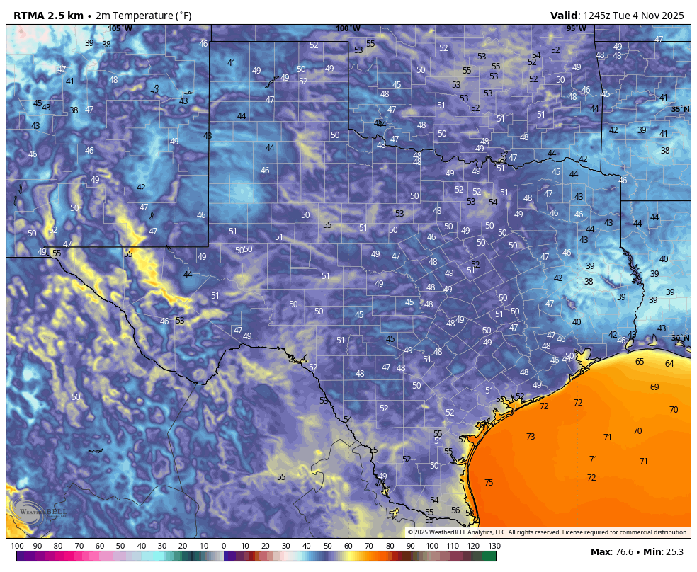
Houston’s forecast is pretty much set for the next week or so. In fact, I would forgive you if you left off checking Space City Weather for a day or two. Really, the only major question I have right now is just how cold temperatures will get early next week, after the arrival of a front next week. The city’s coldest temperature of the fall season, so far, was 47 degrees on Halloween morning. At this time I bet we get colder than that.

Before then we are going to see a gradual warm-up this week, from lows this morning in the vicinity of 50 degrees to lows in the mid-60s this weekend. With high pressure dominating we are going to see mostly sunny to full-on sunny days. We’ll also see gradually more humid air, although nothing oppressive like the region experiences during summer. The front likely arrives on Sunday morning, some time.

Tuesday

Today is going to be an exceptional day, with sunny skies and highs generally in the upper 70s. East winds will shift to come from the south, although remaining fairly light. This is the beginning of the onshore flow, although it will take some time for atmospheric moisture levels to rise. Accordingly humidity will still remain fairly low today. Lows tonight will be warmer, dropping to around 60 degrees in Houston.

Wednesday, Thursday, and Friday

Over this period our daily high temperatures will gradually rise, from about 80 on Wednesday to the mid-80s by Friday (some areas further inland may push into the upper 80s). Really not much more to say. A couple of afternoons may have some wind gusts up to 15 mph. Evenings and mornings won’t be particularly cool, but it will be mild and pleasant to be outside. I’ll be enjoying them.

Saturday and Sunday

The first half of the weekend will bring more warm weather, not unlike Friday. The models have become a little faster with the timing of the front this weekend, and it now looks as though it will come through on Saturday night or Sunday morning. I’ll remain in the “to be determined” camp until there’s some consistency. At this point I think the front will be a dry passage, so I expect a lot of sunshine on Sunday. Look for highs in the upper 70s, probably? I think conditions will be fairly windy, with northerly gusts up to 25 mph, maybe. Lows on Sunday night will probably drop to around 50 degrees in Houston, but I’m writing that in pencil.

Next week

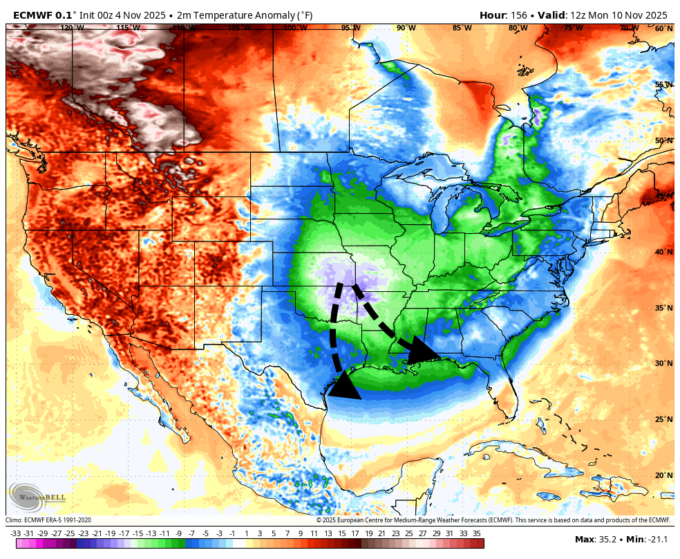
At this point I’m leaning into a “short and sharp” characterization of this front. Matt and I had a little discussion this morning about whether this could be described as an “Arctic” front, as it will be bringing a nose of significantly colder air into the eastern half of the United States. I’m going with a “whiff” of Arctic air, because I do think things could get pretty chilly on Monday night. Houston proper probably holds in the 40s somewhere, but I could see upper 30s for inland areas. It depends on how much of the colder air is pushed due south into Texas, or whether it is shunted off more to the east of us. Anyway, there’s the potential for some rather chilly conditions early next week. I do think temperatures will moderate pretty quicky by Tuesday night or Wednesday, however.

2 Likes

Showing 39F in Liberty and Beaumont this morning, which of course is Radiational cooling. You’d think any brief blast of arctic air would be colder than that next week.

Yo weather, only a few souls care what the temperature is in Liberty and Beaumont.

In the URBAN CORE it was 52 and cold enough. So with new cold advection next week maybe 40s…will have to exchange my flip flops for sneakers. SAD!

As for rain in last 5 years I guess that’s all the time spent in La Niña and very little “El Niño Time”. Lee might need an additional team name. Hoping for some more of that El Niño. Some kind of cycle is driving continuously strong easterly wind in the east and central equatorial Pacific and keeps convection here minimal.

This November is starting off dramatically better than last November :+1::+1:

tumblr_inline_pcsogmRWDq1u77ioz_500

3 Likes

That is correct. We definitely need more El Nino cycles for more consistent rains through the fall winter and spring. With La Nina we get brief wet periods with months of dryness in between. I believe that is one reason the 1950s was so drought stricken in Texas was because we had repeated rounds of La Nina cycles just like the 2020s has been so far.

1 Like

Hey Lee just trying to liven up this new forum. Folks are down to reporting local temperatures now. Needs a little excitement. Can you make us a team El Niño? Team Cumulonimbus is pretty much under staffed in these parts. Most of us don’t even know what those look like

1 Like

I would definitely join team El Nino.

1 Like

Bring on the cold !!!

1 Like

I’m used to thinking of November generally becoming a rather wet month with significant rain, and kind of cloudy/dreary conditions. We’ve been quite dry around here generally - do we see a chance of increased rain as November continues?

1 Like

“….we had repeated rounds of La Nina cycles just like the 2020s has been so far”

Yessir only one year out of the last 5….summer 2023 to summer 2024 was El Niño. Looking at the precipitation chart for 2024 that’s the one year we exceeded “normal”. Why does that happen is the question.

Hoping Lee is coding a Team “El Niño”. Might not be off the shelf but I believe it’s necessary to cheer for better weather here.

2 Likes

November, just like any month in our region can vary drastically year by year. For example, November of 1999 was warm, sunny and dry with most of our area receiving less than an inch of rain, but November of 2000 was the exact opposite. We had multiple cold, cloudy, and rainy days that month with 8 to 10 inches falling regionwide.

But statistically speaking, we do tend to start seeing our first chilly and dreary days in November, but it is not a guarantee every year. And I certainly would not bank on seeing any stretches of cold rainy days this November.

1 Like

2 posts were split to a new topic: El Niño, La Niña — what makes the jet stream move?

All I know is that “El Niño” is Spanish for……..”the Niño.”

3 Likes

Also, @DonJarrett asked @Joseph an interesting question about the jet stream during El Niño, and it’s a great example of a great Weather Talk discussion! I have abused my Discourse moderator privileges and moved the discussion to this location right here. Click through to read and jump in!

It’s all about local temps now. Get the chill and more favorable weather in the country and burbs.

Nicely played, Buckaroo Bonzai!

This topic was automatically closed after 24 hours. New replies are no longer allowed.