Late summer-like weather continues, with some sporadic shower chances

Originally published at: Late summer-like weather continues, with some sporadic shower chances – Space City Weather

In brief: We remain in a September holding pattern (not so patiently) waiting for fall to arrive in Houston. A very weak pattern change may arrive by Friday or so, but set your expectations to ‘very low.’

Monday

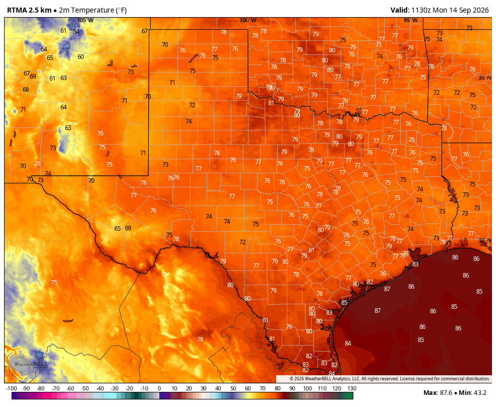
Conditions today will be fairly hot for mid-September, with high temperatures in the low- to mid-90s and mostly sunny skies. There are some widely scattered showers and thunderstorms offshore this morning that should push inland later today, but overall I expect rain coverage to be fairly sparse, likely in the range of 30 percent or so. Winds will be light, from the southwest, at 5 to 10 mph. Overnight lows remain warm, with temperatures only briefly falling into the upper 70s.

Tuesday and Wednesday

The upper-air pattern will favor hot and mostly sunny conditions for the mid-week, with highs in the low- to mid-90s. Rain chances won’t exactly be zero, but they’re likely on the order of 20 percent daily, so for most of us, probably not. Nights remain warm and sultry.

Thursday

We may see a bit of a surge in tropical moisture, and this could help bump up our rain chances a little bit on Thursday, and perhaps increase our cloud coverage a little bit. Overall I would not expect too much in the way of accumulations, but we’ll see. Highs will likely be in the lower 90s.
Friday, Saturday, and Sunday

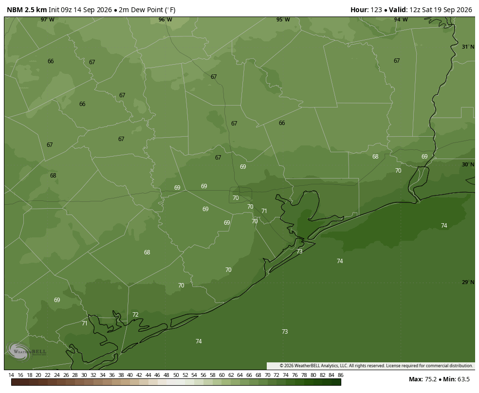
We’ve been on cold-front watch for awhile, and we’re getting closer to that time in September when a front becomes more probable. I had held some hope that we might get a decent front around this coming weekend, and we are likely to see a modest pattern change. But unfortunately it won’t feel particularly fall like. We are likely to see some northeasterly winds on Friday and/or Saturday, and this should knock a little bit out of the humidity. But the effect is going to be really modest, likely only noticeable during the mornings and evenings. Highs are still likely to reach the lower 90s this weekend, with lows in the mid- to upper 70s. Rain chances this weekend are low, probably below 20 percent on each day.

Next week

Overall next week should bring more mostly sunny, late summer-like weather. Look for highs in the vicinity of 90 degrees, with lows in the upper 70s. After a likely rain-free weekend, we may see some daily shower chances return. I wouldn’t rule out some kind of front later next week, but I have very low confidence.
The Atlantic tropics

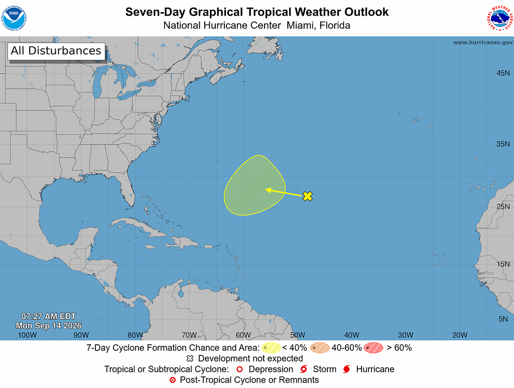
Something vaguely tropical may form out to sea in the open Atlantic this week, but it’s nothing we’re going to have to concern ourselves with in Texas (or the United States). Our remarkably quiet Atlantic season continues.

3 Likes

Fall? I’d settle for some rain, even 1/2 an inch. I think it’s been over three weeks now. Maybe four.

2 Likes

Patience.

Yeah I’m tired of this too. With the Niño boiling in the Pacific, when the Subtropical Jetstream situates over the Southern US in about a month, with Pacific Hurricane moisture and remnants added in, it will be game on. So if you like London like weather for 5 months, your ship is on the way.

2 Likes

I know I’m probably one of the youngest people on this comment section, but I am still old enough to remember when we used to actually get fall like fronts in September. Not a measly little breath of slightly lower humidity with highs in the low 90s and maybe a night or two in the 60s. I’m talking a real cool front that would knock highs down into the 70s or low 80s, with several nights in the 50s.

Now that didn’t happen “every” September back then, but it did more often than not. Nowdays it’s a fluke to get a decent cool front in September. Sadly, it appears that September has officially transitioned into the 4th full time summer month in southeast Texas. Just another reason to hate the warming world. :-1::-1:

3 Likes

Is this warming trend just a texas thing? It seems like the rest of the country for the most part has seasons. Theres places up north that arguably had more of a warm spring instead of a summer.

Anyways based on the numbers ive looked at, there does not seem to be any sign of significant fall front over the next 2 weeks.

When we say “fall front” are we referring to mornings in the low 60s? I think we are probably at least a month away.

2 Likes

4 Likes

I assume you mean “done dry” ???

2 Likes

The warming trend is mostly a global thing, however southern Texas lies right on the cusp of the subtropical high, that has been lingering into the fall months longer as the years go by. The northern states are lucky enough to still be positioned far enough north of this blocking high on an average basis that they can still enjoy cool fronts during the summer and seasonal cold fronts in the fall.

It sort of depends on personal opinion to what you would consider a “fall front”. I would say it qualifies as an early taste of fall of we have one or more nights below 65 degrees and one or two days below 90 degrees, dew points in the 50s and 60s. But “true fall” to me is highs in the 70s and lows in the 50s. Sadly, we have to wait until mid October or later to see such a cool down anymore.

1 Like

Looks like me when waiting on rain to fall again. :sweat_smile:

2 Likes

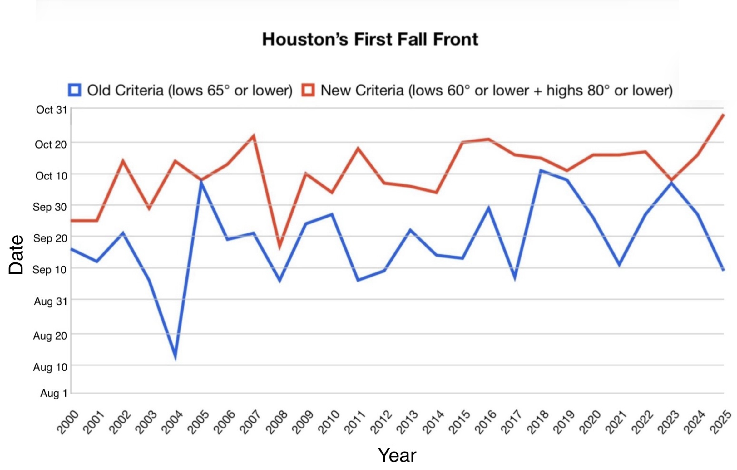
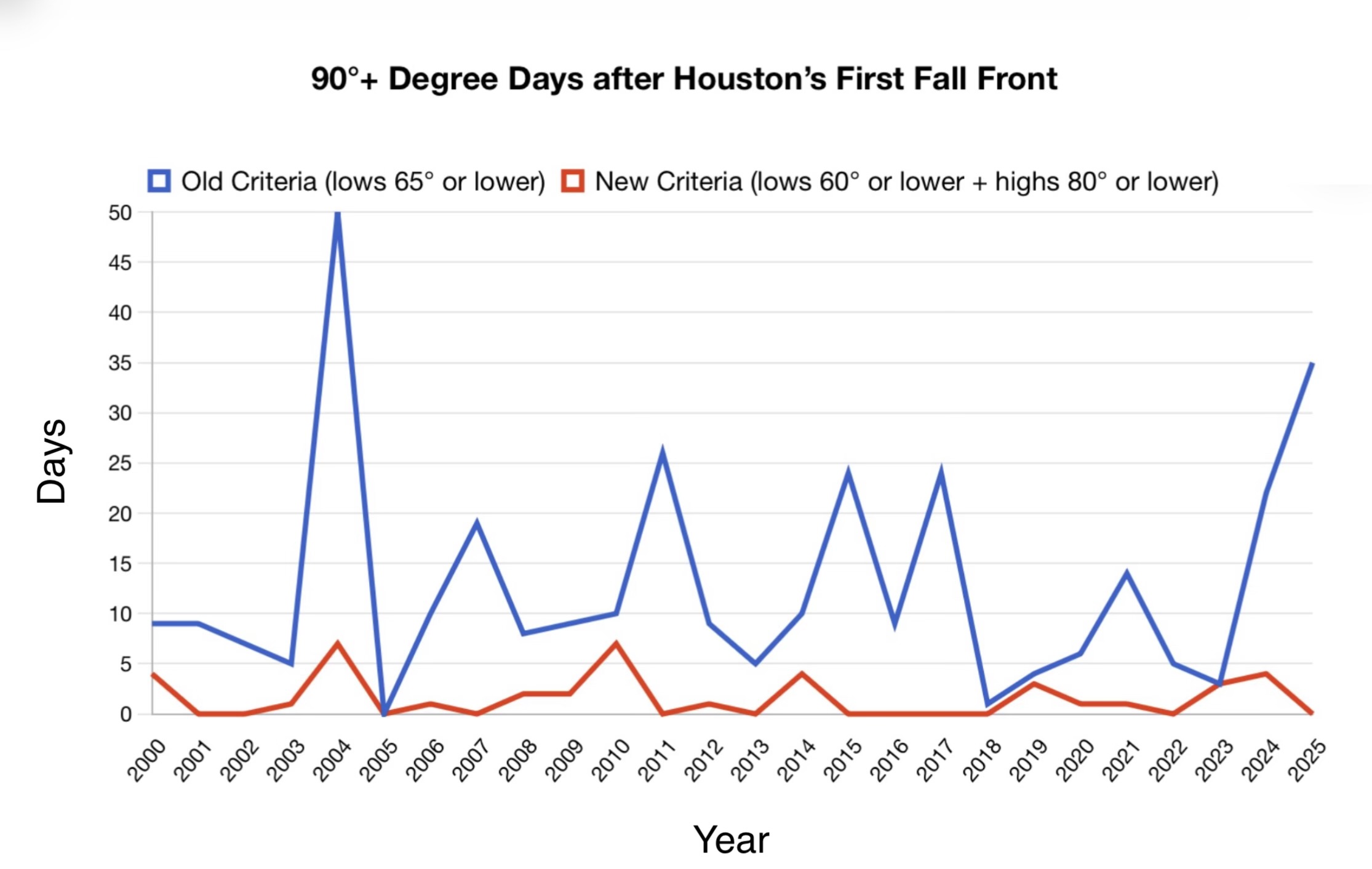
I have the same view as you. I used to classify the first “fall front” when low temperatures reached 65° or lower at Bush Airport (Houston’s official climate site). The average date of this occurring from 2000-2025 is around September 18, but varies widely year to year. However, after reviewing historical data, I don’t think this accurately signals the end of summer. The most glaring example is in 2004 when we had a very unusual strong cold front in August which dropped lows to 65° or lower for 4 mornings (with one low reaching 61°) and highs into the upper 80s. Then we had 50 more days with highs 90°+ until a real season changing front arrived in October.

Because of this, I changed my criteria for the first “fall front” to highs dropping to 80° or lower and lows 60° or lower. I believe this more accurately signals the end of summer and the beginning of fall. The average date using this new criteria is October 11, but the max number of 90°+ degree days after the criteria is met from 2000-2025 is only 7.

4 Likes

We have essentially had 80 degree weather since mid February. This is the longest stretch of warm weather i can remember.

I’ve always felt like September & October in Houston should be call Tease-tember & Tease-tober! Even when we get that first front, it’s back to hot & humid in a jiffy! at least for a bit, which your plots show well.

I like your reasoning to come up with some real criteria to measure this by! I think most of us are much too subjective when we remember how things “used” to be. It’s a natural human trait to forgot past struggles, especially the “minor” ones which have only become minor with the passage of time.

2 Likes

I’m really worried about the climate in Houston. It feels like few other places in the country are warming as fast and aggressively as Houston. CFS monthly now has above average temps continuing into the end of the year. The negative PDO might be powerful enough to cancel out the El Niño thsi winter. I’m very concerned that this will result in another year without a fall or winter. 99 in Houston today. Average temps (91/71 for today) are just so utterly meaningless in this climate.

3 Likes

Yeah I remember that nice front in August 2004. That led to the warmest October on record to this day. Early cool fronts in August and even September definitely do not signal the end of summer in SE Texas and never really have. Historically, summer almost always returned to some degree in early to mid October. Thats why I often say that our actual fall month is November.

I just miss when we used to have atleast a little bit of relief from the swampy stickiness in September, even knowing it would still return before the fall fully set in.

1 Like

This topic was automatically closed after 24 hours. New replies are no longer allowed.