Houston in the haze as steamy summer days continue

Originally published at: Houston in the haze as steamy summer days continue – Space City Weather

In brief: Smoke and dust creating a hazy situation around Houston this weekend will likely continue into early next week. But also a slight change will allow for some minor rain chances to return after the weekend.

The weather in Houston can only be described right now as very typical late June or July. It’s hot and humid but not overly so. We have already seen some Saharan dust, but we’re also seeing a lot of haze aloft that is almost certainly related to ongoing Western U.S. wildfires.
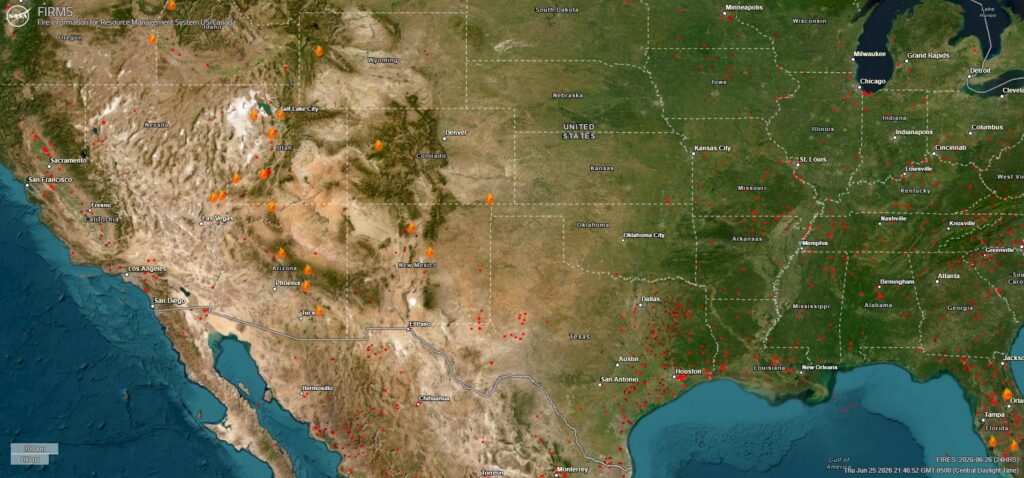
This acrid looking mix of smoke, dust, and haze will persist through the weekend, only accentuated by a burst of Saharan dust by later Sunday or Monday.

Today & weekend

Not a whole lot of change in things expected here, with sun, heat, humidity, and haze. Saharan dust thickens up a bit as Sunday progresses. Shower chances are minimal. That’s about it. We’ll keep it simple today.

Next week

As we head into Monday and Tuesday, a sprawling area of upper-level high pressure is going to establish itself over the Ohio and Mississippi Valleys, bringing a pretty hefty heat wave to parts of the Midwest, Mid-South, and East Coast. Houston will be positioned on the southwest periphery of that high pressure. For us, that does a couple things.
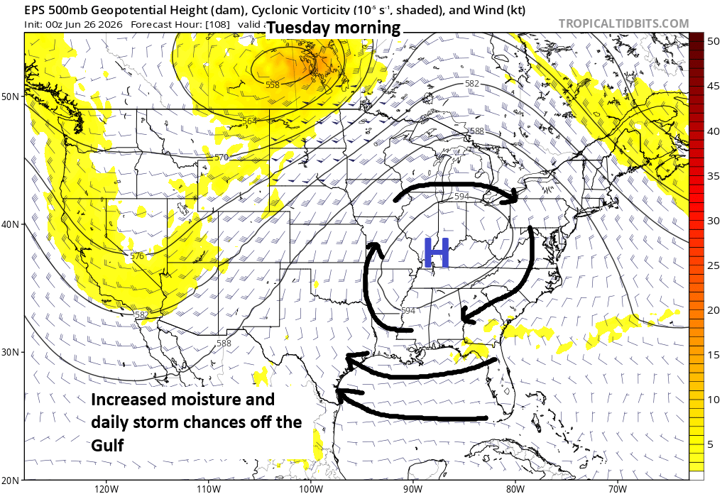
First, it should open the door to the Gulf a bit. This will allow for the typical splash and dash summer thunderstorms we get here in Houston to re-enter the picture by Tuesday or Wednesday. Second, it will allow for the Saharan dust plume to blow into the area early in the week. Smoke from the western wildfires should hopefully diminish some. Also, it means that if any tropical waves enter the Gulf, they could be pointed toward the Gulf Coast. By Wednesday or Thursday, that’s a possibility, and although development of any significance is not expected, it could help nudge up our rain chances a little for the middle to end of the week. Or it could mostly end up in Louisiana. Both are reasonable potential outcomes. We’ll watch this weekend to see how things go.

Either way, by our 250th birthday next weekend, we’ll probably see that Gulf connection back off a bit as high pressure shifts out of the Midwest, with somewhat hotter, drier weather returning to Texas.

Drought update

The rains of late have definitely done wonders for our drought situation in Texas. Most of the state is now free of drought, with the notable exception of the Panhandle and portions of northeast and interior central and south Texas. The last time the majority of Texas was free of “abnormally dry” or worse conditions was September of last year.
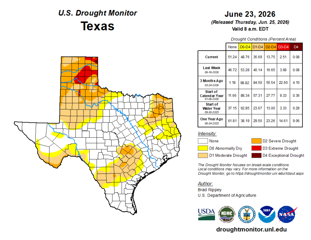
Lake Corpus Christi is about 33 percent full now, up from 14 percent a month ago. While Choke Canyon is still in very poor shape (below 10 percent full), the other reservoirs are picking up the slack and buying some time before what will hopefully be a wetter winter in South Texas. We shall see.

3 Likes

Possibly a dumb question, but why would the Saharan Dust choke out hurricanes but not put a damper on the typical rainstorms that form over the Gulf and move in?

1 Like

It’s not a dumb question, it’s actually a good one. This may not be 100% accurate but I think the main reason the Saharan dust layer suppresses hurricanes and not the typical rainstorms that develop in the Gulf or the seabreeze is the fact that there is usually strong windshear involved with the SAL, which destabilizes the vertical lift needed for a storm to organize into a rotating cyclone. This would happen with or without the dust layer involved.

The dust itself can reduce hurricanes strength by cooling the water underneath, which limits the convective lift. The dust can also dry out the atmosphere which can also weaken the convection needed to power a strong hurricane.

However, There is also some evidence to support that this Saharan dust can actually exacerbate the intense rainfall with tropical systems that do manage to fully develop because the fine dirt particles give more stuff for water droplets to develop on.

So my final conclusion is that the the Saharan dust by itself is not exactly a death sentence for hurricanes, but combined with a few other factors, it can definitely contribute to shutting down or weaking hurricanes from developing further. It probably won’t do much to prevent a typical tropical wave from bringing heavy rains to coastal regions, but you have a lower chance of said tropical wave/tropical low developing into a Hurricane.

2 Likes

@Joseph This may or may not have anything to do with it, but could it also be a warm core vs. a cold core type of thing? What fuels a thunderstorm is a little different from what fuels a hurricane?

1 Like

That is a great point. I don’t know for sure 100%, but I suspect that the SAL would probably not have much of an effect on cold core lows since they are driven by the collision of different airmasses rather than the convection of hot ocean water. But they still could have a measureable effect. For example, the dust could make cold core lows a bit drier than they normally would be by reducing the moisture in the atmosphere and weaking the instability at the surface from the slight cooling effect of the dirt cloud reflecting some sunlight away from the ground. Regular pop up storms off the sea breeze could be slightly affected as well for similar reasons.

But then there is also that possibility of the dust actually making some systems wetter from the increased particles for water vapor to condense onto So, I feel like it’s sort of a toss up and maybe the experts will have a better answer. :man_shrugging::sweat_smile:

1 Like

Generally agree with the stuff here. But I do think there is some impact. Just as dust (SAL) does not necessarily prevent tropical systems (it merely acts to limit their intensification), it can offer a layer of dry air aloft that helps to suppress thunderstorm coverage somewhat. One thing about next week is that the bulk of the SAL hits Sunday/Monday and front runs the change to more onshore flow. So that means when our storm chances increase, most of the dust will be out of the system here. Never any stupid questions!!

2 Likes

@Matt Thank you Matt!

This topic was automatically closed after 24 hours. New replies are no longer allowed.