Flood risk ends for Houston, but a major event is unfolding in Central Texas

Originally published at: Flood risk ends for Houston, but a major event is unfolding in Central Texas – Space City Weather

In brief: Houston’s flood risk has ended, but we’re tracking a flash flood emergency in Central Texas, near Kerrville, that is unfolding just a year after catastrophic flooding in similar areas. Locally, clouds will give way to sunshine in the coming days, bringing Houston some of its hottest weather of the year.

Guadalupe River flooding

Things have quieted down in Houston over the last 24 hours, and although we are likely to see some scattered showers over the next couple of days, the region’s flood risk has ended. The story is not the same in Central Texas, where a significant flooding event is unfolding.
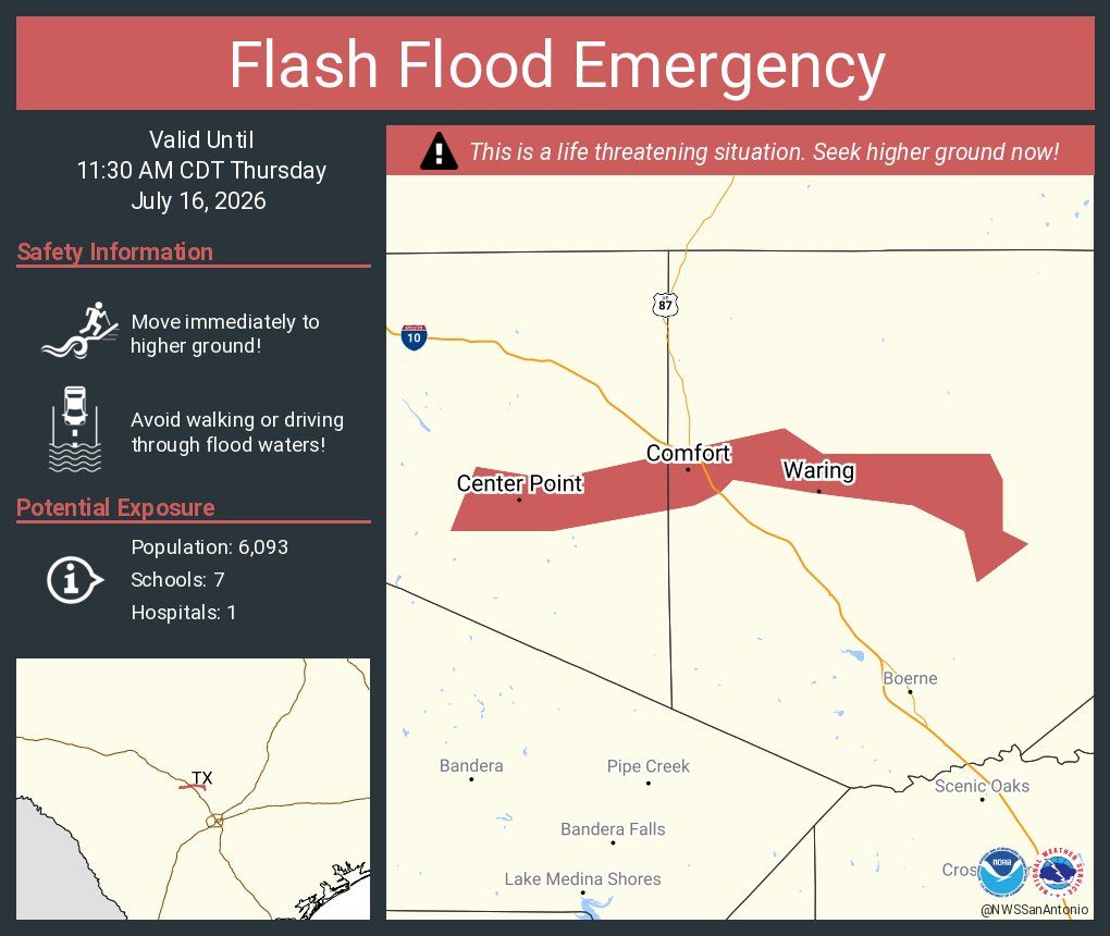
At 5:30 am CT this morning the National Weather Service office there issued a “flash flood emergency” for a stretch along the Guadalupe River, to the north of San Antonio. The emergency area runs from the town of Center Point through Bergheim. A gauge at Center Point has risen 32 feet during just the last four hours. According to forecasters, the river is expected to reach a crest similar to the July 4, 2025 catastrophic river flood in that region. Additionally, for Uvalde County, catastrophic flooding is likely along the Frio, Leona, Sabinal, and Nueces rivers.

A flash flood emergency is the weather service’s highest level of flood alert, and they are rarely issued. Such alerts are triggered by rapidly rising water that poses an imminent threat to people.

Thursday

Closer to Houston this morning we are seeing some additional showers to our southwest, near Victoria and El Campo. Generally, I don’t expect these to move into the Houston region, and for the metro area we should only see isolated to scattered showers and thunderstorms today. Your overall chance of seeing rain is probably about 20 percent. Our skies will likely remain partly to mostly cloudy, however, and this should help limit high temperatures in the lower 90s. Winds will be light, from the southeast. Low temperatures tonight will only briefly drop into the upper 70s.

Friday

We’ll have another slight chance of showers and thunderstorms on Friday, but the trend will be toward clearing skies. Accordingly I expect high temperatures to reach the low- to mid-90s across Houston. Low though it may be, this is probably our final chance for rain for a week.

Saturday and Sunday

Summer proper returns to Houston this weekend, with mostly sunny skies and highs in the mid- to upper-90s. Need I say more? Prepare yourselves accordingly.
Next week

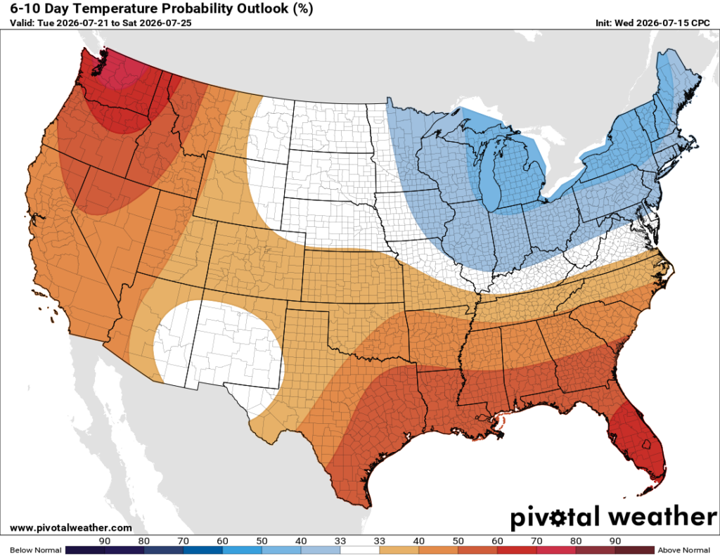
We are going to see our hottest weather of the year, to date, next week. Highs for several days will push into the upper 90s, and some inland areas may touch 100 degrees for the first time. I expect mostly sunny skies. If there’s a silver lining it’s that dewpoints will not be quite as high as they can get during the summertime in Houston, so our nighttime temperatures may cool into the mid-70s rather than just falling to 80 degrees. It’s not much, I know. Rain chances remain near zero until at least Thursday or Friday of next week.

3 Likes

I’ve received over 6 inches of rain in my backyard since Saturday. This is the perfect situation to be in with the heat dome about to set in.

2 Likes

It doesn’t sound like much but there actually can be a big difference between a morning low of 75 vs 80, especially if the sky is clear.

1 Like

How long will GOES satellite be down, been down since yesterday afternoon

That 5 degrees is like night and day. Vegetation and animals need that relief

4 Likes

I like it when you write about the monthly Climatological Report at the start of each month.

June had an average high temperature of 90.4 (versus 91.0 historical), average low temperature of 77.6 (versus 74.9 historical), and mean temperature of 84.0 (82.9 historical).

How common is it for us to have that type of deviation? It seems ‘normal’ to me, but I haven’t calculated anything myself.

AVERAGE WIND SPEED, 9.2
AVERAGE SKY COVER, 0.59
AVERAGE RH (PERCENT), 78

What about humidity, clouds, and wind? I’d be curious how those metrics affect our perception of how nice it is outside.

2 Likes

I follow the monthly Climate Reports closely. While our average high temp can fluctuate a bit with respect to historical mean, it is a virtual certainty that our average low temperature will exceed the historical average in the summertime. The urban heat island effect makes it near impossible for the city to cool off at night like it did 50 years ago.

I know it’s hard to believe, but us long-timers will remember it actually cooled off at night and was crisp on many summer mornings before Houston really exploded. I’m talking about when I was a kid circa 1960s and 70s.

1 Like

I believe you. The historical data supports that. Whenever I go to the park early in the morning I feel cooler air, which is assume is because the trees and grass radiate heat to the sky.

What about warmer temperatures of surface water temperature from the gulf? My theory is that warmer gulf temperatures lead to warmer nights. It also makes sense that urban heating contributes. I wonder which is a bigger contributor.

2 Likes

It is true that the urban sprawl leads to warmer nights inside the city; however, overnight lows have been getting warmer on average for rural areas as well in summer especially along the immediate coastline. For example, Palacios has been recording many more overnight lows in the 80s during the summer months than they did decades ago. And the Palacios airport is sitting in the middle of the same open filed it was in the early 40s. There is no urban heat island effect there.

This is due to the Gulf warming up more than it used to. This leads to higher evaporation rates, which means higher water vapor content filtering inland. Water vapor is the Earth’s most potent greenhouse gas by far. So, as the climate continues to warm, this feed back loop will inevitably intensify, meaning nights in the 70s during summer will become less and less common over time in southeast Texas, even for rural areas.

1 Like

Thr urban heat island effect is the biggest contributor inside the big city, but the warmer Gulf waters likely adds an extra punch as well. For rural areas the warmer Gulf is absolutely the main culprit for warmer nights overall.

1 Like

I have been fortunate that last summer and so far this summer I have yet to see a low of 80°F or above in JV. Some nights came close, however. And I know those nights are numbered, unfortunately.

100 Degrees. Oh, goody.

This topic was automatically closed after 24 hours. New replies are no longer allowed.