Drought slowly creeping into Houston, with slightly cooler temps and more dryness expected into next week

Originally published at: Drought slowly creeping into Houston, with slightly cooler temps and more dryness expected into next week – Space City Weather

In brief: Dry weather will continue in the Houston area for the foreseeable future with warm to hot afternoons and somewhat pleasant mornings. Drought is expanding in Houston now, and with that comes some elevated wildfire risk, particularly today north and east of Houston. Thankfully, winds look generally light on land.

Good morning, and if you’ve stepped outside this morning, it really does feel kind of good! Much of the area is seeing temperatures in the 60s this morning.
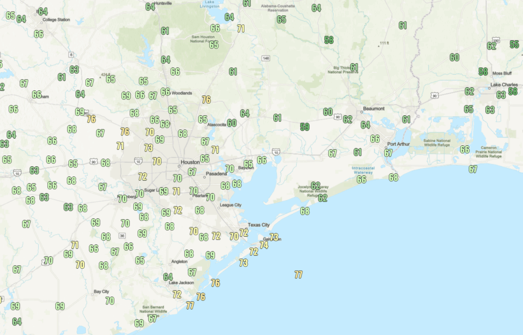
Tonight should be even a bit cooler. Low humidity will allow for cooler nights and continued warm to hot days heading into next week.

Drought update

A couple notes on that drier air: First off, drought has finally begun to creep into the Houston area.
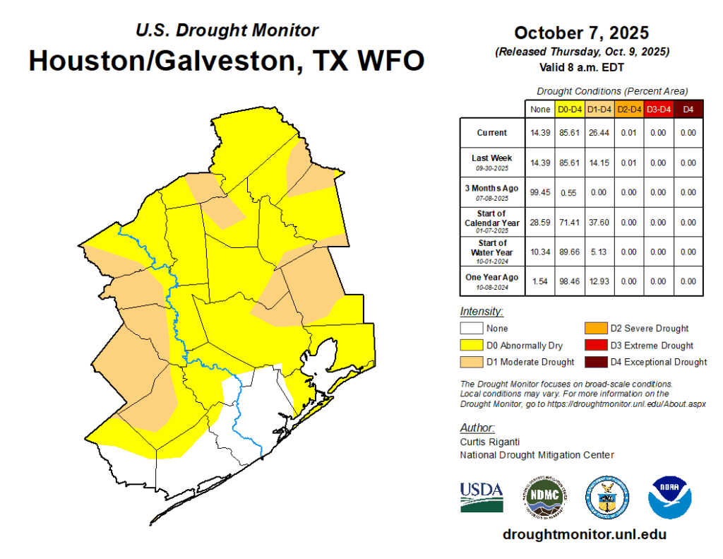
We’ve seen some drought on the fringes, but that has now begun creeping into the immediate metro. With no rain expected over the next week, this should continue to slowly expand. Thankfully, we were able to bank some rain this summer due to the frequent cadence of daily storms. But that only gets you so far once you get to autumn.

Wildfire risk

Because of this dry, less humid weather and expanding drought, human-caused wildfire risk is somewhat elevated, particularly today and possibly tomorrow. Please continue to use extreme caution outdoors when it comes to anything that could lead to a fire. Thankfully the winds are well below Red Flag Warning criteria, but even still, this is a reminder that wildfires can and have happened here before.
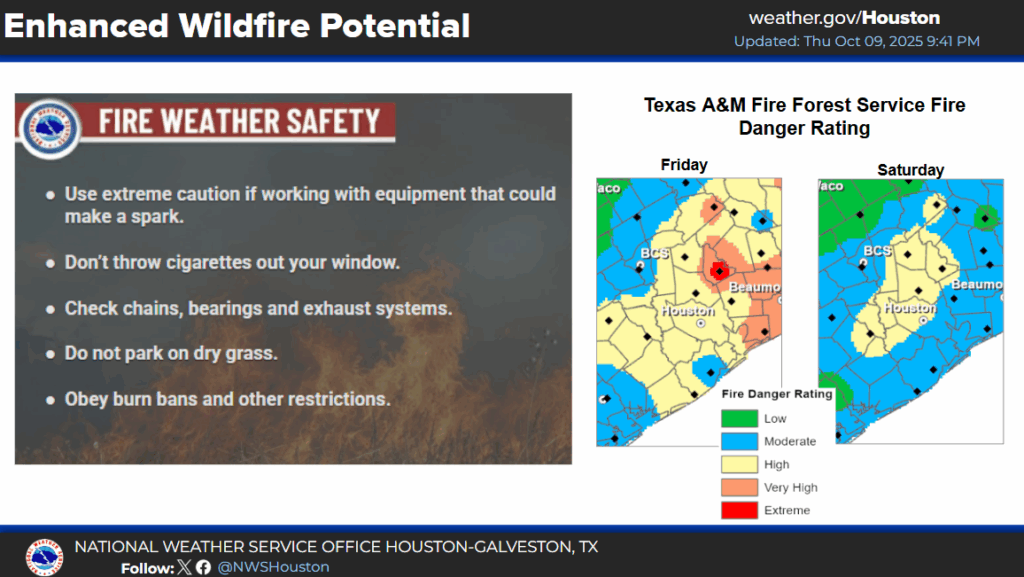
Humidity levels increase enough to suppress wildfire risk after tomorrow. We may get a brief reinforcing “cool” front next week, but aside from that, today should be the most elevated day for fire risk for a bit.

Forecast notes

The forecast is pretty straightforward other than what we’ve discussed above! We expect little to no rain over the next 7 to 10 days. Daytime highs will be in the upper 80s to low 90s. Morning lows will be in the lower 60s tomorrow, then mid to upper 60s heading into next week. Not a whole lot of risk or wrinkles to this forecast right now. So, expect sunshine, occasional ozone alerts, and continued bad allergy weather. Both the good and the bad in early October in Houston.

2 Likes

I always thought Houston was a fairly wet area with above average rainfall, but since I’ve lived here it seems like we’ve had a lot of droughts.

Seems like it’s feast or famine with rain for us. Rarely just a week of off/on light rain :confused:

2 Likes

OMG the ragweed!!! :melting_face:

2 Likes

Does anyone know why it seems like this warm air just hovers over our area? The rest of the country seems to be having fall and even winter. But this warm air just stays put over SE Texas.

1 Like

This is just part for the course with a La Nina fall unfortunately.

That’s sort of how it’s always been in this region. We go through frequent periods of drought, sometimes a very long periods, then we get hammered with a ton of rain all at once. The 1950s, for example, was the worst long-term drought in the states recorded history, only to be quickly replaced by major river floods in 1957.

There is very little happy mediums when it comes to rain or temperatures in SE Texas. The extremes have been a bit more pronounced in recent years but the rule is still the same.

1 Like

There is a blocking upper level high that has been draped over Texas for a while now. In English, this means that the air in the mid and upper levels of the atmosphere has expanded over a good chunk of the southern United States and is holding the jet stream winds north of Texas. The much cooler fall air is essentially being steered far north of Texas, leaving us stuck under warm dry Pacific air and warm muggy Gulf air. This tends to be a common trope with La Nina Octobers.

The next drought is always around the corner here. Remember all the rain we received late spring/early summer? Doesn’t take long for that to disappear into the rear view mirror here. I wasn’t here yet, but I remember people talking about the 2011 drought - which really began the previous fall/winter with well below normal rainfall.

2 Likes

My son and his wife just moved up to Minnesota, and even up there it’s been warmer than normal. It was pushing 90/low 90s last weekend before a cool front finally seeped through. The Twin Cities Marathon was last weekend and the morning temps mirrored what we see here, with starting temps in the 70s and 60s dew points. They are starting to see a bit more of fall finally this week, with Tuesday morning dipping down to around 30-32 degrees in the TC’s area.

2 Likes

Man that must be nice! We won’t get cool weather like that here until December if we are lucky. Lol

2 Likes

Up until 2023, the record for the most 90-degree days in October was 10. Last year we had 18. We already have 9 this October and will probably add 10 or so more the way things look.

Also, up until 2023, the record average high for October was 86.6° set in 2016. Last year we blew it out of the water, with an average high for the month of 89.8°. We may beat the record for the 2nd year in a row and possibly finish with an average high above 90.0° in October for the first time in recorded history… assuming there’s no super strong cold front at the very end of the month.

3 Likes

In west Montgomery county we haven’t had meaningful rain in over 2 months now.

@gjanke Hopefully soon!

This topic was automatically closed after 24 hours. New replies are no longer allowed.