Originally published at: The tropics are waking back up, but hurricane season is nearing its end for Texas – Space City Weather
In brief: Today’s post discusses the state of the Atlantic tropics, which are waking up after an uncharacteristic snooze to start September. We also talk about the persistent pattern of late summer weather here in Houston.
State of the tropics
After the Atlantic tropics have slumbered for nearly three weeks (Tropical Storm Fernand gave up the ghost on August 28), we are close to seeing the formation of a new named storm in the open Atlantic. This would be Gabrielle, and it likely will become a hurricane over the next few days. This storm could well threaten Bermuda early next week, but it otherwise is unlikely to approach any landmasses.
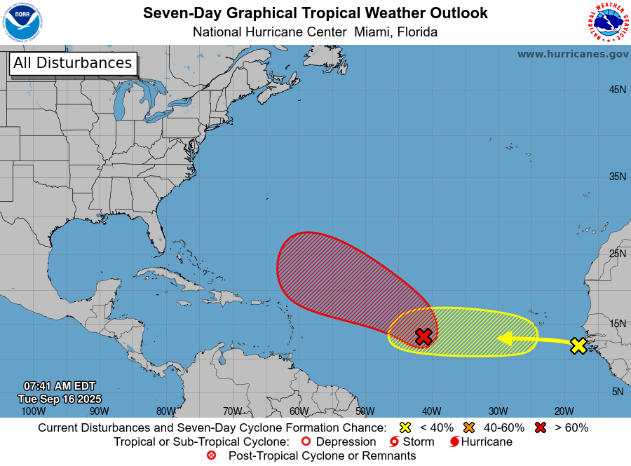
Beyond this storm there is another system behind it, a tropical wave that is just now moving off the coast of Africa and into the eastern Atlantic Ocean. The global forecast models are divided about whether this system will develop, and for now the National Hurricane Center gives it about a 20 percent chance over the next week. This is something to watch to be sure as we are in the middle of September, but nothing to be really concerned about at this point.
The window for hurricanes to strike Texas is closing, but it is not closing yet. I want to wait another week or 10 days before making that call. The only thing I’m really concerned about now, and to be clear this is a very mild concern, is the potential for something to develop in the western Caribbean Sea or southern Gulf, and for such a system to move north toward the state. But again, this is a low probability event.
Tuesday
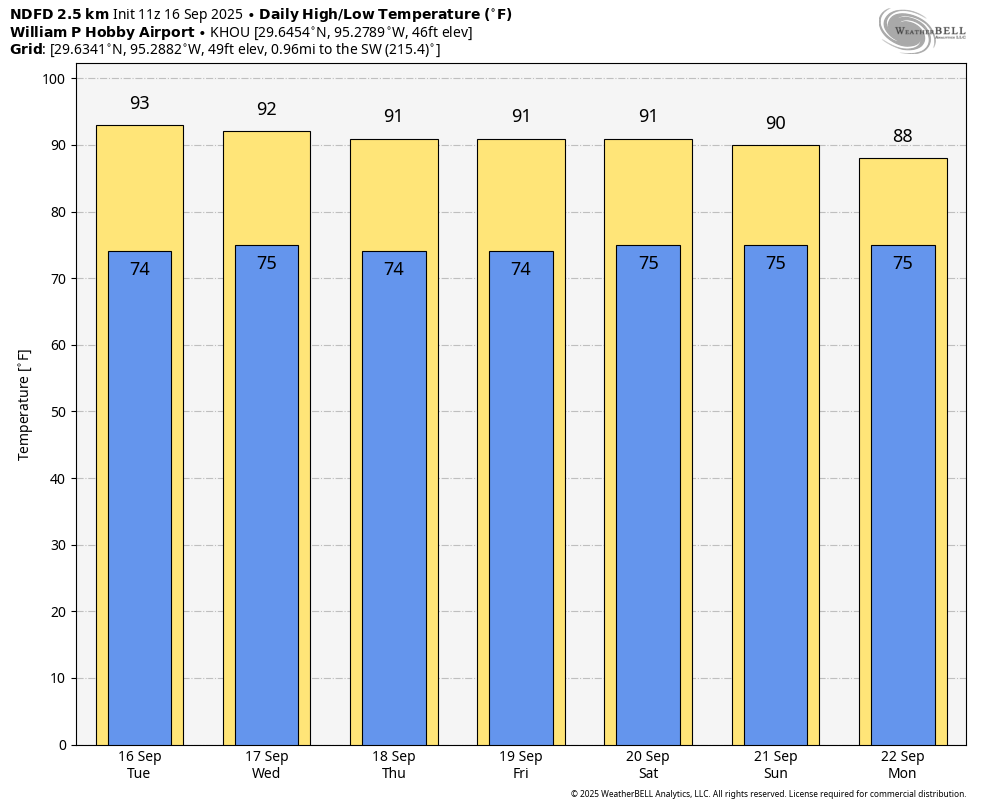
If you’re looking for new and exciting changes with Houston’s forecast, I’m sorry to disappoint you. Houston remains locked in the same late summer pattern of warm days, mild nights, and mostly sunny skies. It does look as though we will start to see some better rain chances by early next week, but for the most part the likelihood of seeing rain for the next few days will be on the order of 10 or 20 percent. Highs today will be in the low 90s in Houston, with far inland areas perhaps seeing mid-90s, and the coast topping out around 90. With dewpoints in the 60s the humidity will be up there, but it won’t be “summer sticky.” Winds will be light, generally from the east. Lows tonight will drop into the mid-70s.
Wednesday, Thursday, and Friday
And so it will go for the rest of the work week. Highs might be a degree or two cooler as we approach Friday, but most of the region should still reach the lower 90s, with mostly sunny skies. Nights remain in the mid-70s. Rain chances are low, but non-zero.
Saturday and Sunday
High temperatures this weekend will be about 90 degrees, so a smidgeon cooler, but I think that will be accompanied by a slight rise in humidity. There are some chances for isolated to scattered showers, perhaps on the order of 20 to 30 percent for both days, with the better chances toward the coast. But these should be fairly short lived, if they develop. Skies should still be mostly sunny, most of the time.
Next week
Our pattern next week may finally shift a little. Highs are likely to be around 90 degrees, with better rain chances on Monday (maybe as high as 50 percent?) We could see partly sunny skies for much of next week, with scattered daily showers. I’m still not seeing a strong signal for the next cold front, so late summer will probably be sticking around for awhile.