Houston's weather: Hot for a few more days, then rainy, and then we cool off

Originally published at: Houston’s weather: Hot for a few more days, then rainy, and then we cool off – Space City Weather

In brief: Houston faces a couple of more days of late summer weather before a significant pattern change brings us a soggy weekend. After that we expect cooler conditions next week. Is it goodbye 90s?

Tuesday

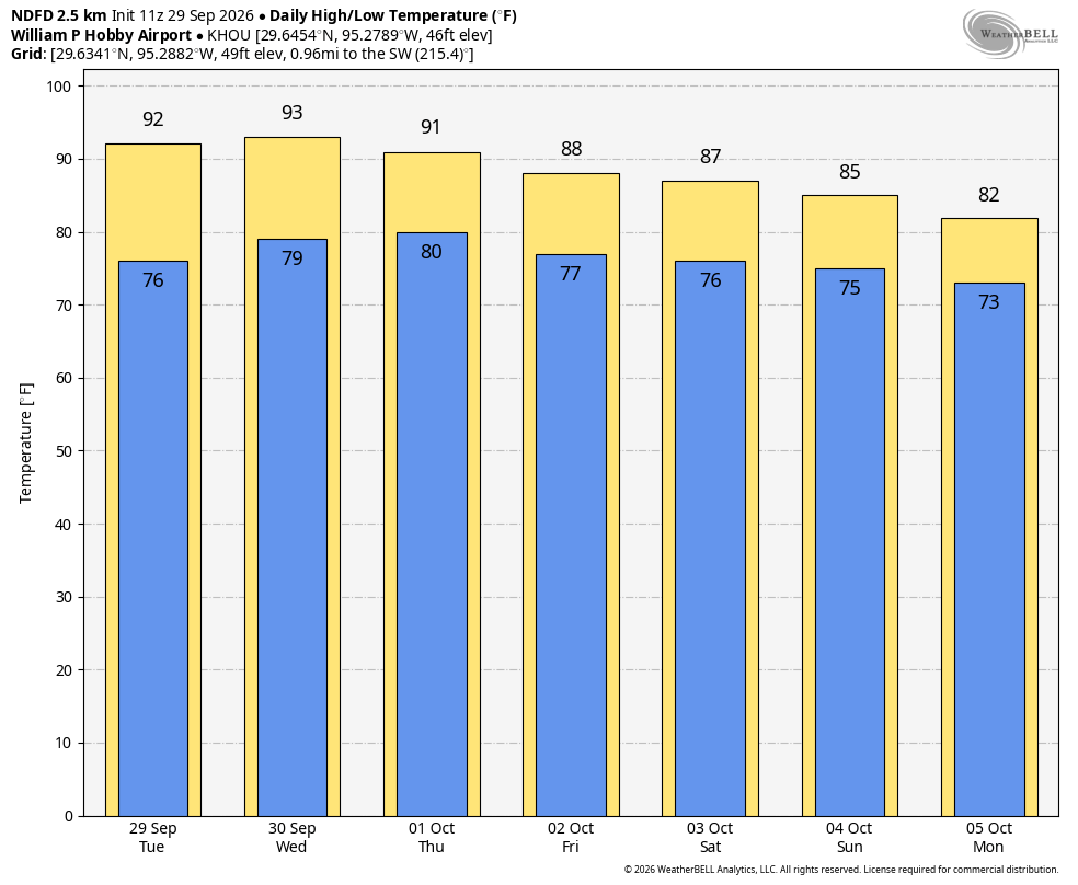
Today will bring partly sunny skies into the region, with high temperatures in the low- to mid-90s as late September heat stubbornly holds on for a few more days. Winds will be from the southwest, gusting up to 15 or 20 mph during the afternoon hours. Areas near Matagorda Bay may see a few showers, but overall chances closer to Houston, and within the metro area, look to be low today—probably in the 10 to 20 percent range. Lows tonight will only drop into the upper 70s, and briefly.

As for the Astros and their playoffs against the Chicago White Sox, with games here locally on Tuesday, Wednesday, and Thursday, I would not expect the roof to be open at all for the AL Wild Card Series.
Wednesday

This day will be similar to Tuesday, although rain chances will be slightly higher, perhaps in the 20 to 30 percent range. Expect another muggy night.

Thursday

Skies should transition to become mostly cloudy on Thursday, with highs likely in the vicinity of 90 degrees. Rain chances will be improving, but as we discussed yesterday, the bulk of the rains during the mid-week period will be concentrated over central Texas, due to moisture from the remnants of Hurricane Polo. I’d say the region has about a 50 percent chance of rain on Thursday, but the likelihood of heavier rainfall will not pick up until Friday, or the weekend.
Friday, Saturday, and Sunday

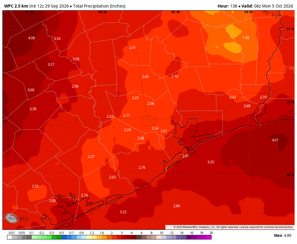
This is when atmospheric moisture peaks, and each of these days will see a healthy rain chance in the 60 to 80 percent range. Overall accumulations this weekend will likely be in the vicinity of 1 to 4 inches across the metro area, but some areas may see higher isolated totals. For now we are not going to issue a flood scale warning, but Matt and I are watching things closely to see how things evolve. Mostly, we think this just will be a soggy weekend, with on-and-off showers putting a damper on some outdoor activities. Due to rains and cloud cover, expect highs in the mid- to upper-80s this weekend, with overnight lows in the 70s.

Next week

Highs next week should remain in the 80s, and our nighttime temperatures will depend on the extent to which a series of fronts make it into the region. Right now I think it’s possible that a weak front makes it in on Monday or Tuesday, with the possibility of a another front later in the week. The details on all of this are very much fuzzy at this point, however.

4 Likes

1-4 inches is a big spread. Bank on the low end folks, and hope for the high end.

2 Likes

Did we even have a single day this entire September with a daily high under 90F? I’m not sure we did.

2 Likes

Just the 1st and the 6th at Bush Airport. And it actually managed to drop down to 69 degreees on the 26th.

2 Likes

I still see no fall front on the horizon. Please dont let the tv meteorologist make you believe mid 80s is a fall front. :tired_face:

2 Likes

Soon, the time will come to redefine “fall fronts”.

2 Likes

Lately, I’ve been dividing forecast rainfall by about ten to get what will actually fall.

2 Likes

That’s another thing forecasts are missing on. For example, Wunderground forecasted a high of 88 for me this afternoon. It’s already 92.

2 Likes

Could some please explain why, during an ongoing super El Niño, when it is supposed to be cooler and wetter than average, it is instead hotter and drier? There is finally a storm system on the horizon, and the models show it getting blocked before it reaches us by an eastward moving system over the Gulf. What happened to the stronger than average subtropical jet stream that’s supposed to bring storm systems through?

1 Like

I don’t know where you’re located but it was not supposed to be only 88° today, LOL. I had Houston getting to 94° today. National Weather Service has 93-95° in Harris County.

We’re still only in September. It’s a little early for El Nino’s effects to take hold.

Weather forecasts and Wall Street predictions are both wrong 50% of the time.

I think the key miss was they were showing cloudy all morning, with rain in the afternoon, but it’s been sunny.

And yet many retirement funds are based on Wall Street performance.

Wunderground has a definite cold bias, especially in the summer. You can, pretty reliably, add 4-5 degrees to their temps on most days.

I see clouds out my window, but no rain yet. Maybe a spot off in the far distance.

It is a bit early in the season still. The effects of El Nino on the jet stream usually don’t begin until mid to late October or November. It can vary though.

1 Like

Thanks to Doc Brown for easing up on the lightning rod so we could get underneath this training rain today. Much needed and much welcome inch so far. Most rain we’ve had since early August.

Let’s see what the next week monthly report says from NOAA PSL. Wind anomalies and OLR index have been flat since May-June. Although SSTs are strong (and hyped) we really need to see evidence that the ocean is communicating with the atmosphere. Otherwise it’s just warmer water.

That is, the Walker circulation has been disrupted and Pacific convection has moved east. It’ll happen… but how strong and when is still not known.

2 Likes

WOW talk about hitting the jackpot yet again here in the SL/Mo City area, despite the 10-20% chance noted above. Definitely got a couple inches in the last 2 hours, all the streets are backed up and low visibility driving

2 Likes