Houston's heavy rain and storm chances will increase again Saturday night through Monday

Originally published at: Houston’s heavy rain and storm chances will increase again Saturday night through Monday – Space City Weather

In brief: While rain totals across the Houston area have been rather variable (ranging from less than an inch in some spots to over 8 inches in far southern Brazoria County), we expect everyone to participate in rain and storm chances this weekend, especially from Saturday night into Monday. Flash flooding remains a distinct possibility, and our Stage 2 flood alert will remain up through at least Monday.

Rainy pattern check-up

We’re a few days into this relatively significant change to a rainy pattern, and so far, so good for the most part. We’re going to maintain the Stage 2 flood alert through the holiday weekend. I think the rains we saw Wednesday down in Brazoria County (7 inches) exemplify what this setup is capable of.
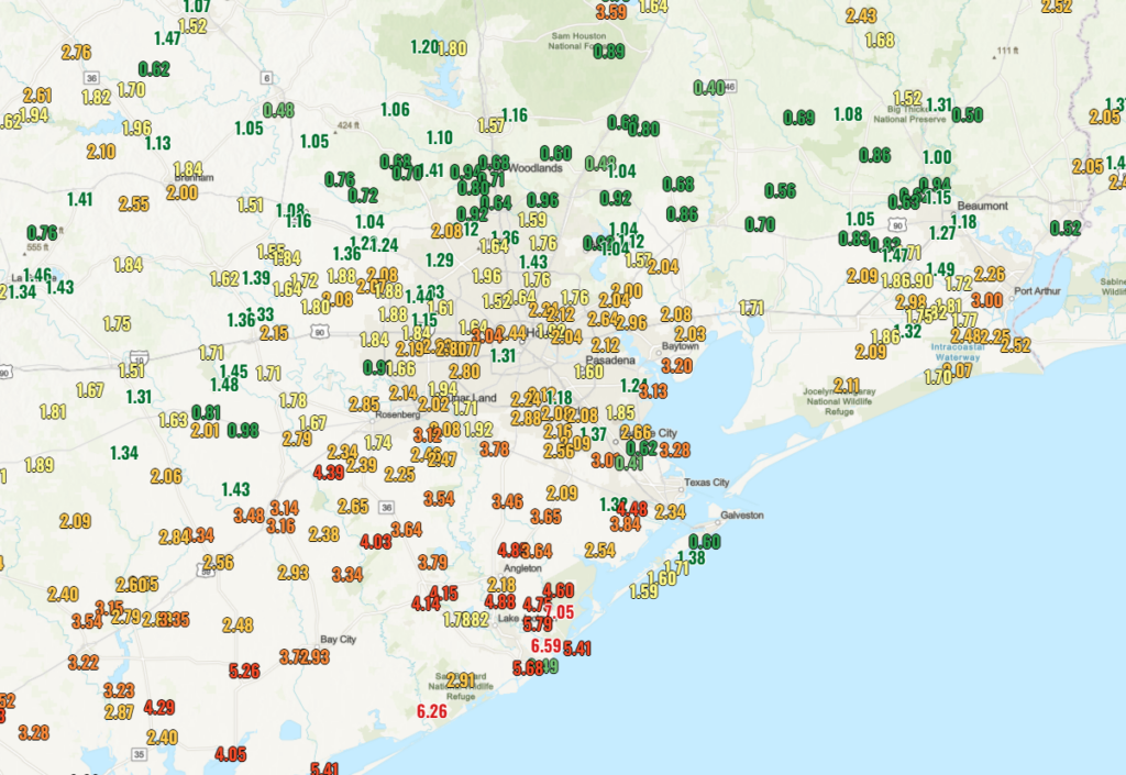
So far, the northern half of the area has seen a relatively pedestrian 1 to 2 inches (even less in spots), while the southern half has seen 1 to 4 inches on average, with pockets of 5 to 8 inches. We expect another 1 to 4 inches on average over the next week across the entire area. Isolated higher and a couple lower amounts are indeed possible.

For those concerned about the situation in Corpus Christi, Lake Texana has seen about 3 inches of rain, while Lake Corpus Christi has seen about 4 inches of rain so far. Areas upstream of those lakes have received anywhere from 2 to 4 inches as well. By no means does this “save” Corpus Christi from a very bad situation, but it obviously helps buy some time. And any help is great news down there right now.

Today through tomorrow afternoon

Right now, weather modeling is suspiciously calm today and much of Saturday across the area. Obviously, showers and thunderstorms are still possible. But I would suspect most places stay dry as the best “oomph” for storms remains south or offshore in the Gulf. We’ll probably see clouds and sun. Highs may nudge back up into the middle or even some upper-80s after a couple days of lower 80s. There will be plentiful humidity to go along with that.

Saturday night through Monday

If we’re going to get smacked by rainfall, Saturday evening through Memorial Day would be the timeframe I’d be watching closest. A rather vigorous disturbance in the middle and upper atmosphere is going to swing into the Houston area on Saturday evening. This should provide the trigger necessary to get storms off and running. It’s impossible to really say exactly how things are going to setup right now, but expect increasing thunderstorm chances after about 4 PM on Saturday into Saturday night across the Houston area.
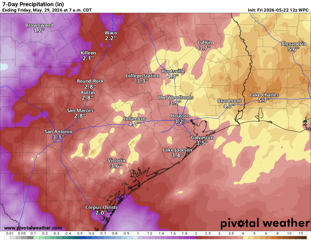
We’ll then need to watch for repeated development of storms and the risk for flash flooding, including in areas that have not seen much rain so far. With moisture in the atmosphere much higher than normal, any storms will be capable of dropping 2 to 4 inches of rain in an hour or so. Any “training” or repeating thunderstorms over the same area means those totals could add up quickly, hence the concern for some localized flooding and our Stage 2 flood alert. More to come on this throughout the weekend as we get more clarity on timing and locations impacted.

Next week

The area will remain under the influence of an unsettled weather pattern and above normal atmospheric moisture. I would expect this on again/off again type rain and storm stuff to continue through much of next week, though perhaps at a slightly slower pace. Either way, what we can say with fairly high confidence right now is that any sustained, strong early summer heat is not in the cards through at least early June.

2 Likes

Geez check out Louisiana! Hope no one had plans to travel that way this weekend.

Are today and Saturday kind of a bust or were we always expecting them to not be as rainy?

Also, if they are kind of “a bust” does that mean Sunday and Monday could be as well, or is that more guaranteed?

Or is this all up to the natural uncertainty of weather forecasting?

Signed, a user who mowed Monday night because they thought everyday would be rainy after that!!

Yesterday the forecast (per NWS) was 4-6 in over the weekend, today that shifted to Louisiana and it’s like 1-3 in here. Can someone tell me why they always over-forecast rainfall?

Harris County FWS shows just shy of 2", over the past 7 days, for my area near Katy. I’m hoping for more. What we have gotten has been the good slow soaker type of rain, so I’m not complaining at all!

2 Likes

Heading to ComicPalooza in the morning, out at the GRB tomorrow. Really hoping the rain holds off enough to get inside. Will be there around 10am. :crossed_fingers:t2::crossed_fingers:t2::crossed_fingers:t2:

1 Like

How are the bayous that protect the Houston Metro, such as Buffalo, White Oak, etc.? If Downtown or Galleria gets a huge fast rain, do these bayous have some capacity or are they already near full?

Matt_J, They’re pretty empty, but you can track real-time status here

1 Like

Sigh, here we go, google is free. For those who are already complaining and ready to call the weather forcasted over the past few days a “bust”.

A forecast is a prediction or estimate of future events, often based on data, trends, or observation. It is commonly used in meteorology to predict weather.

I remember when we were forcasted in Houston to get hit by Harvey, anxiously waiting the night before, woke up the next morning and the sun was brightly shining. I was so confused but stayed home anyway, unfortunately so many people chose not to, called it a bust and hit the streets. Many lives were lost, or almost, lost so I say it is your choice to take heed or stay aware of what is being “forecasted”!

Anything that staves off the blistering heat that will inevitably arrive as long as possible, I am all for.

3 Likes

*Forecasted

Spellcheck is also free.

1 Like

@Sunny63 Yes. There is more than one way a weather forecast can be “tricky,” not necessarily a bust. For example, yesterday morning almost all of the rain was south of I-10. For those of us south of I-10 it certainly was not a bust but what about north of I-10? A bust? That’s the tricky part. Technically I would not call it a bust. Where the rain sets up can be very difficult to pinpoint. And what about TV meteorologists? They have to come up with one forecast for an entire viewing area, which covers a lot of area. What happens in Montgomery County on a given day may be very different from what happens in Galveston. There is no formal forecast saying “forecast for north of I-10, forecast for south of I-10, forecast for west of I-45, forecast for east of I-45, etc.”

2 Likes

The issue is that the forecasts are off on the large-scale systems as well, not just the exact placement of the mesoscale-level thunderstorm complexes. The forecast center of the heavy rainfall shifted from central & southeast Texas to Louisiana & over the Gulf over the past couple days.

Of course, maybe tomorrow will prove the flood watch warranted after all, who knows.

1 Like

What Harvey are you remembering?? I remember the forecast calling for heavy rain pretty much every day and that’s what happened.

Also no one blames SCW for a busted forecast that is based off of a computer model.

This topic was automatically closed after 24 hours. New replies are no longer allowed.