Houston records its first freeze since February as region receives glancing blow from an Arctic blast

Originally published at: Houston records its first freeze since February as region receives glancing blow from an Arctic blast – Space City Weather

In brief: In today’s post we discuss the city’s first freeze in 10 months, and how our region narrowly missed out on an Arctic blast. Our attention then turns to the potential for some light showers on Wednesday, and another brief incursion of cooler air Friday before a warm run-up to Christmas Day.

City officially records a brief freeze

It took most of the night, but according to unofficial data this morning, the thermometer at Bush Intercontinental Airport reached 32 degrees at 6:10 am CT Monday. This is the city’s first freeze since February 20. If we look at average freeze dates, since the official monitoring station was moved to Bush airport in 1969, the average date of the first freeze is December 4. So we are a little late this year, but not too late.

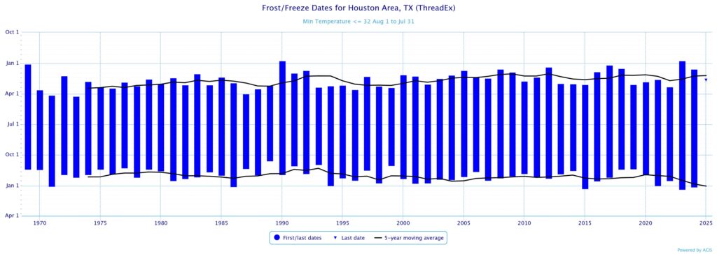
Not all of Houston fell below freezing this morning. Much of the city’s urban core along and south of I-10, as expected, appears to have remained just above freezing this morning. Galveston Island, as of sunrise, is a balmy 36 degrees. This is the peak of the cold for now, and probably will end up being our coldest day this December.

This front was part of fairly strong Arctic outbreak, but in the end this colder air was driven down into the United States and shoved east and southeast, rather than continuing all the way down into Texas. Accordingly we are seeing low 20s in southern Mississippi, Georgia, and the Carolinas this morning rather than Texas. That could easily have been us. This is plenty cold for me.

Monday

Although air temperatures are very chilly this morning, at least winds have fallen off. They will remain more or less light today and tonight, although they will subtly shift to come from the east. We will see mostly sunny skies today, with high temperatures in the mid-50s. Lows tonight should be 3 to 5 degrees warmer than Sunday night, so we do not anticipate another freeze in the region.

Tuesday

After a chilly start this will be a mostly cloudy day, with highs in the mid-60s. Southeasterly winds will herald the arrival of a more robust onshore flow. Lows on Tuesday night will only drop into the 50s.

Wednesday and Thursday

These will be a pair of warmer, and more humid days. Wednesday should have a few more clouds, and potentially some light showers (expect accumulations of less than one-quarter inch, for most), and this could help limit highs in the mid-70s. Thursday will have a little more sunshine, I think, and this may allow temperatures to push upwards of 80 degrees. At some point on Thursday night a cool front will push through, so we probably will wake up to chillier conditions on Friday morning. It should be a dry passage.

Friday

This will be a short-lived front, but it will make things feel seasonal on Friday. I’d expect morning lows in the vicinity of 50 degrees, followed by a sunny day in the 60s. Lows on Friday night should, once again, drop to around 50 degrees. This will likely be our final visitation of winter-like weather until after the Christmas holiday.

Saturday, Sunday, and beyond

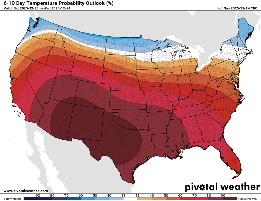
After this the most likely scenario is about a week of warm and (for December) fairly humid weather. We are talking about highs in the 70s (possibly pushing 80 some days) and lows in the 60s. Skies will be partly cloudy with the occasional odd chance at some light rain showers. It is not completely out of the question that we see some sort of front during the run-up to Christmas, but at this point I would not put chances above 10 percent. So yeah, by far the most likely outcome for Christmas Day is highs in the upper 70s, with the potential for a foggy start. There is some evidence of a pattern change prior to the start of the new year, but that is far enough into the future such that I have low confidence in the forecast.

“In seed time learn, in harvest teach, in winter enjoy.” —William Blake

After enduring the long hot Houston summer the recent colder weather has been enjoyable. Unfortunately it looks like the remainder of this year will be warmer and muggy. In addition as soon as the wind changes direction and blows off the cooler waters of the Gulf it will bring sea fog as thick as pea soup!

1 Like

Anybody else noticing the decent fall foliage we’ve been getting this year? Not sure how it is elsewhere in the metro, but NW Houston is sporting some serious yellow, orange, and even red color. And no, it’s not the drought this time.

6 Likes

I’ve noticed a bit of that, I went walking in Huntsville State Park last week and there was some. I always appreciate it so much here since we usually don’t seem to get a lot of it.

2 Likes

While I and my tropical plants don’t like 35F, I prefer it this time of year to 75. Come on.

2 Likes

This is incredible. After tomorrow we will be having temperatures in the high 70s/low 80s for probably the next 2 weeks. This is mind blowing.

2 Likes

This is mind blowing

THIS… IS… SPARTA HOUSTON!

3 Likes

This is just how winter is in southeast Texas now. Ever since 2016, most of our winters have been loaded full of days in the 80s with sticky nights in the 60s/70s. Like way more frequently than before. We can still get extended periods of cold weather but it is usually comprised into just one month. January has been the most reliable month for consistently cold conditions over the past 10 years and sometimes February.

As I’ve said before, until I see a true change back to the old-school winters we used to get, I don’t think this will ever change. It will probably just get worse as the tropics continue to heat up. My guess is that we will probably experience the warmest 2nd half of December on record this year or atleast come close. The below average temperatures we’ve experienced this month so far will be all for not now.

3 Likes

Yes, I noticed on Saturday while driving to an event down here in Clear Lake. It felt so magical and I took so many pictures of all the beautiful trees.

2 Likes

Remember when December 2022 had an insanely warm first half? This is that but flipped the other way around and milder on both ends.

3 Likes

Correct me if I’m wrong. It bottomed out at 35°F this morning in Jersey Village and there was no frost. I’m thinking that there was just enough wind to prevent the frost and to keep the temperature a couple of degrees or so warmer.

1 Like

It has been so annoying driving to work through it at 4:30 in the morning. Over the past week there were a few times where I could barley see in front of my windshield. Down here along the coast the sea fog can get scary thick. :fog: :skull_and_crossbones:

2 Likes

@Joseph There’s been a little of that here, but not as bad. I think more is expected by the weekend and next week. My wife grew up in southern California along the coast and it was very, very common there. She can remember her mother driving and having to roll down her window and poke her head out to try and see where she was going.

1 Like

All of the stations I’m seeing in Jersey Village show 33° as the low, but regardless the air was too dry for frost. Dew points were in the low 20s last night. The ground surface is not going to cool 10-12 degrees below ambient especially with the 5-8 mph wind last night.

2 Likes

Believe it or not it actually dropped down to 28 degrees at the Angleton airport. Everywhere else was between 32 and 34.

1 Like

@JFS Thanks, I did not know how dry it was. Of course, my reading of 35°F is unofficial. The thermometer I have now is the most accurate one I’ve ever had.

1 Like

Yep, and temperatures can vary in small areas depending on where your thermometer is. It is typically going to be colder out in the middle of the yard in areas that are exposed to the sky. On the back porch thermometers will typically read a few degrees warmer especially if its a covered backporch. Also, I believe thermometers can pick up on the warmth from your house if you have it close to the wall.

This topic was automatically closed after 24 hours. New replies are no longer allowed.