Originally published at: Houston now very likely to experience a hard freeze this weekend, with the potential for freezing rain and icy roads – Space City Weather
In brief: In today’s post we go in depth on the timing, and potential impacts of a winter storm this weekend. Before then we also have a widespread chance of showers today in the Houston area, with warmer conditions expected through at least Friday afternoon.
Winter storm status
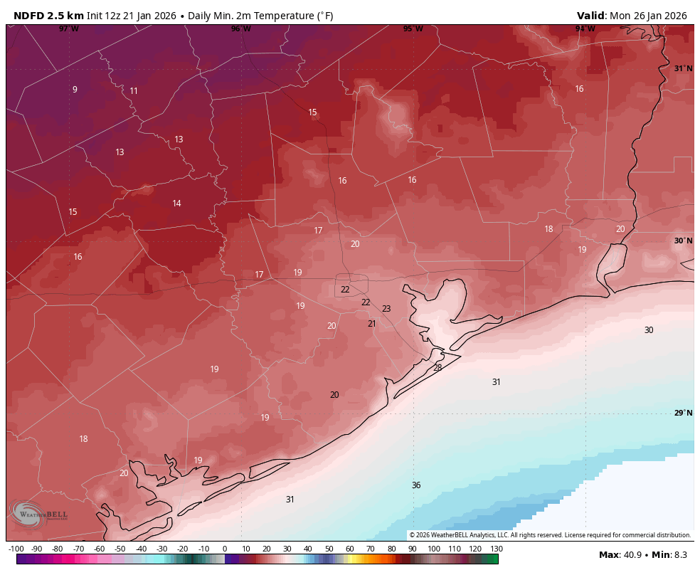
Based upon the latest modeling data we are increasingly confident in a hard freeze for the majority of the Houston metro area this weekend, for all but the immediate coast. It now appears likely that Texas will see a direct shot of Arctic air, rather than a glancing blow. This means that large parts of the region will likely experience temperatures of 25 degrees, or below, on Saturday, Sunday, and possibly Monday nights. For some inland areas, such as Katy, Cypress, and The Woodlands, temperatures in the upper teens are possible. Actions to protect pipes and vegetation should be taken.
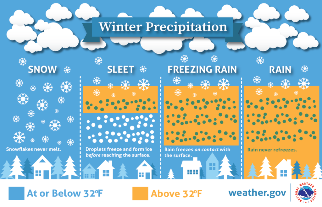
As for freezing precipitation, it remains a close call, but we think mobility impacts are increasingly likely around and within Houston. Freezing rain will be likely to the west and north of Houston, in Waller, Grimes, Montgomery and Liberty counties. I think the jury is still out on Harris County and points closer to the coast. However, by Saturday afternoon or early evening, this will be a distinct possibility and you should factor that into your travel plans around the area—i.e. have a contingency plan to remain in place. More on the timing of this below.
Note we attempted to answer some common questions about the impending freeze in a post published Tuesday afternoon.
Wednesday
At sunrise this morning we have a mass of moderate showers to the northwest of the region, having just passed through College Station. These are associated with a weak (and dying) front that will sag into Houston today. Accordingly I expect light to moderate showers throughout the day in our region, although accumulations for most will be on the order of a few tenths of an inch. So expect no serious impacts. Highs will near 70 degrees for most locations, with cloudy skies, and light southerly winds. Rain chances slacken this evening, with lows tonight only dropping to around 60 degrees.
Thursday
This will be a warm and fairly muggy day, with highs likely in the low 70s. We can probably expect some fog early on Thursday, as well as a slight chance of showers throughout the day. Skies will remain mostly cloudy, but we might see a spec of sunshine during the afternoon. Lows on Thursday night will again only drop into the vicinity of 60 degrees, so more fog is possible.
Friday
This will be another warm day with a fair bit of humidity. The morning hours will likely be rain free, but we should see some scattered showers later in the day. These chances will increase on Friday evening and overnight as the front approaches. Highs on Friday will be in the range of 70 degrees, with temperatures falling sharply as the front moves through. If you’re planning to drive to the Dallas or Austin areas this weekend, I would advise you to arrive there by or before midnight on Friday evening, at which time ice could start to accumulate on streets.
Saturday
One of the big uncertainties I still have concerns the timing of the front moving into the Houston region. There is a world in which the colder air does not arrive in the city itself until midday Saturday, but I think it is more likely to move in earlier, perhaps around sunrise. We’ll see. Anyway I think air temperatures will remain above freezing throughout the daytime in the city, allowing for normal mobility despite widespread showers. For areas west and north of the city, such as Montgomery and Waller counties, freezing temperatures appear to be possible starting Saturday afternoon, so please be flexible in terms of your plans this weekend.
Whether we see freezing rain on Saturday afternoon and Saturday night depends on how quickly the cold air moves in, and how quickly the precipitation exits to the east. I think the best advice I can give you is to be prepared for the possibility of ice on roads in Houston from late Saturday afternoon onward. That does not mean it is certain, but it is distinctly possible with wet roads and falling temperatures. Lows on Saturday night will fall into the 20s, most likely, but whether that’s the low 20s or upper 20s will depend on how close you live to the coast.
Sunday
This will be a very cold day. Highs for many locations may not reach above freezing (32 degrees), or do so only briefly. My best guess is that the precipitation will exit our region some time between midnight on Saturday and noon on Sunday. Given the confluence of freezing air and moisture on roadways, I think it reasonable to expect, at a minimum, icy patches on roadways on Sunday. It could be worse, and we could have a full blown ice rink out there. But for now we can’t say for sure. The bottom line is that mobility on Sunday, even in Houston, will be a big question mark. Sunday night looks to be the coldest night of the period, with lows dropping to 20 to 25 degrees in urban parts of Houston, with cooler temperatures outside the city.
Monday
We will finally see some sunshine on Monday. I know everyone would like to know what the roads will look like on Monday, but that will depend on a lot of factors that are difficult to predict. If you’re trying to make plans for school, or work, or otherwise on Monday morning, it is definitely possible that there is some lingering ice from the weekend’s rain. It will depend on the amount of precipitation, how warm temperatures get Sunday, efforts to clear streets, and other factors I don’t feel confident in predicting. But yes, there’s the potential for impacts. With mostly sunny skies and highs in at least the upper 30s on Monday I think we can finally clear most ice impacts later in the day. Monday night will be very cold again, with temperatures likely dropping into the 20s again.
Next week
The rest of next week should see conditions moderate a little, with highs in the 50s and lows in the 30s, or thereabouts. But the bottom line is that it will remain quite cold for the remainder of January.
Our next update will be published by 3 pm CT on Wednesday afternoon.
