Houston faces a good chance of storms, heavy rainfall overnight

Originally published at: Houston faces a good chance of storms, heavy rainfall overnight – Space City Weather

In brief: After a mostly quiet Tuesday, the potential for widespread showers and thunderstorms will increase tonight and into Wednesday morning. Here’s our latest thinking.

This post will only cover the forecast for Tuesday evening through Wednesday morning. However, in the big picture, not much has changed with our forecast through Memorial Day weekend. We still expect periods of widespread and, at-times heavy rainfall. Our Stage 2 flood scale alert remains in effect through that time.

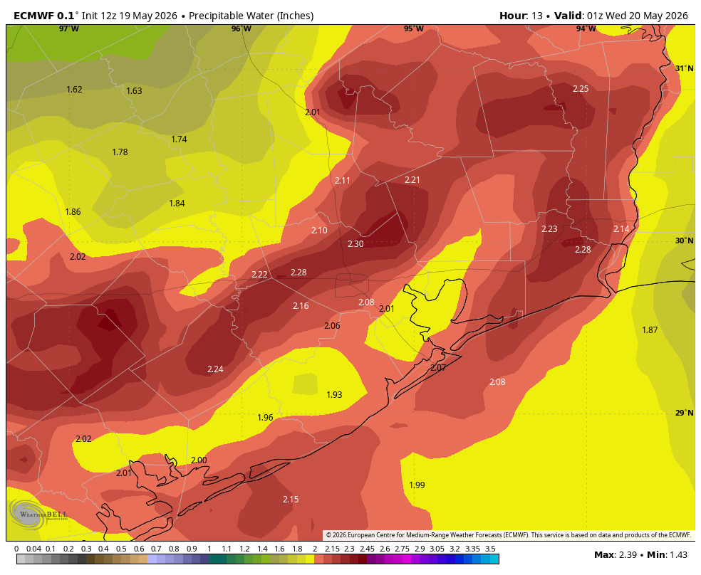
As for tonight, we still do not have great confidence in the finer details of the forecast. But there are a lot of red flags out there, including an atmosphere that is extremely rich with moisture, an approaching (but dying) front, and a fair amount of instability. This, typically, leads to moderate to heavy rainfall. There’s still a chance this could bust, but I do feel as though the region will see some activity tonight.

As a best guess, I think we’ll see a line of storms, possibly broken, form north of Houston roughly along Highway 105 tonight around midnight, or maybe a bit before. This line of storms should then move southward shortly after midnight. Possibly we could see some damaging winds within the stronger storms, but the bigger threat is heavy rainfall. Whether those storms hold together all the way through the Houston metro area and down to the coast is not entirely clear, but that mess should be moving offshore before sunrise.

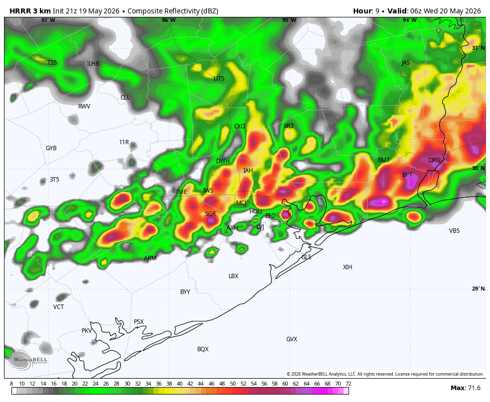
Even as it does so, another mass of showers and thunderstorms may advance into Houston from the west. Most of our guidance indicates that the threat of rainfall from these storms will be highest along and south of Interstate 10, so basically areas closer to the coast. These storms could reach Houston around sunrise on Wednesday, give or take a couple of hours, before weakening. Or maybe the atmosphere will already be too worked over for them to have too much impact.

Again, there’s a fair amount of guesswork here, but we wanted you to be aware of the potential for heavy rainfall overnight—amounts will vary broadly, from 0.5 inch to 4 inches (maybe) in isolated areas—and into Wednesday morning.

We’ll be back by 7 am with a full forecast for you.

2 Likes

Incoming!!! Gulley Washer! Duct Tape the Pool Noodles to the top of the Truck and Look under the covers for your dogs if they are found to be suddendly absent when the thunder rolls in!!!

I cleaned the storm drains out in the yard Eric, so I’m ready!

Latest model runs say no rain tonight. I’ll go with that.

I’m thankful it looks like there will be a little of some lulls here and there over the next few days and not consistent downpours. Hopefully that will help mitigate flooding a bit. Maybe.

1 Like

Outflow boundary just knocked the humidity out of the air in JV and lowered the temperature to 74°F. Rain is imminent, finally on the move. The storms to the north did weaken some. No boxes.

1 Like

Woohoo things are picking in the Sam Houston Pkwy and Memorial area! :dashing_away::cloud_with_lightning:

1 Like

During SCW’s tenure, has Houston metro ever seen a pattern like this one, where 12" falls in a week, and then another 12" falls in the following week? Wondering if 8 days from now a quick 1/2" shower will put water into homes. I can’t recall a two week stretch where each day brought major league rain.

1 Like

I am pretty sure that has never happened atleast in recorded history for Houston, just from the extensive research I have done. Now, extreme rainfalls of 20+ inches have fallen in the Houston area in just a few days primarily from Tropical Storm Alison and Hurricane Harvey, but not spread out over 2 weeks.

However, some pretty fierce weather extremes have happened throughout history long before we started collecting data, so I’m sure at some point the land that surrounds the current Houston area has seen excessive rains drawn out over 2 weeks at some point several times before.

I don’t know. The Tax Day floods were 24 inches in about 24 hours. That’s going to cause chaos, no matter what. I think the way this is set up over the next week plus, that there’s rain, then it lets up, is going to be to our benefit on the flooding side. Our soils should be able to pretty well handle most of the water, I would think. It will be soggy, but if we’re supposed to have a hotter and drier summer, I’m all of the rain now.

1 Like

This topic was automatically closed after 24 hours. New replies are no longer allowed.