Originally published at: Forecast comes into better focus as tropical system will soon emerge into Gulf – Space City Weather
In brief: We expect widespread showers and thunderstorms today, particularly south of I-10, where flash flooding is possible. Our current thinking is that a tropical disturbance expected to track across the Western Gulf on Wednesday will remain far enough offshore to spare Houston from significant flooding, but we’re going to watch things closely.
Behold, the tropics
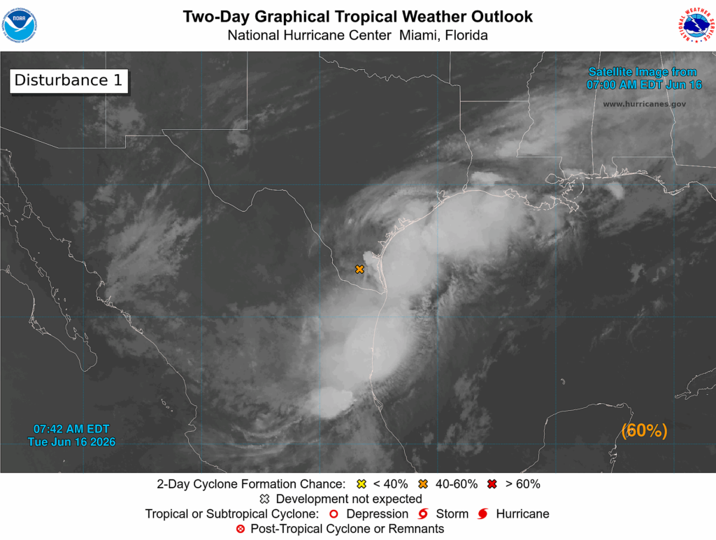
As of this morning a low pressure system located over South Texas is starting to move toward the Gulf. On Wednesday it should move to the northeast, just off the Texas coast, toward Louisiana. At this time it may have a brief period during which it can spin up into a tropical depression, or possibly a named storm (it would be called Arthur). The National Hurricane predicts there is a 60 percent chance this occurs. Although certainly there would be a lot of noise around a tropical storm forming in the Gulf so close to Texas, we’re here to tell you the impacts from this system are going to be similar regardless of its development in the coming days.
And there’s some good news in the forecast. Remember how we’ve been talking about the boom or bust potential later this week, on Wednesday and Thursday, due to heavy rains from this tropical system? As of Tuesday morning we are leaning toward bust. Put another way, after today and this evening, our rain chances will probably trend down somewhat. And we think the likelihood of very heavy rainfall (i.e. bullseyes of 10 inches or above on Wednesday and Thursday) in the Houston metro area is low. It’s not zero yet, but things are trending in the right direction. There will be some winds and tides to contend with, but nothing too significant. More on that below.
Tuesday
In terms of heavy rainfall, conditions will be most favorable today across the Houston region with rich tropical moisture spreading into the area. There is a thick band of heavy rainfall offshore the Texas coast this morning, spreading all the way from Corpus Christi to Port Arthur. The key word there is offshore. Some of this activity is spreading inland this morning, and we expect rains to move into the Houston area today. Due to the tropical nature of this airmass, rainfall rates could be quite high, quickly leading to street flooding (and hence, our Stage 2 flood alert).
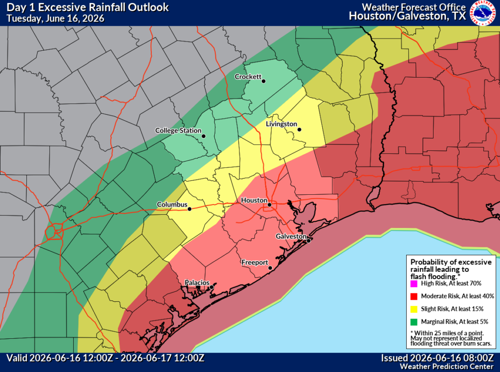
Rain accumulations today should be highest along and to the south of Interstate 10. In these locations 2 to 4 inches of rain will be possible, with some isolated areas of 6 inches possible. Further north totals should be less. Due to the rain-cooled air mass temperatures today for most locations should be in the 80s, with lower 80s likely near the coast. Rain chances should slacken somewhat overnight, but there will still be pockets of activity.
Wednesday
The aforementioned tropical system should pass closest to Houston on Wednesday. At this time we think it will track southeast of our region, remaining off the coast. In this case it should keep the heaviest rains offshore. The major risk at this time is if the system tracks more to the north, and moves inland into the Upper Texas coast. This would mean more rain over the Houston metro area. To be clear, we don’t think this will happen, but we are watching for this possibility and will of course keep you informed.
Anyway, our best-guess forecast at this time for Wednesday is for about a 60 percent chance of rain showers, with better chances and higher accumulations closer to the coast. For now rain totals look fairly manageable, with 1 to 2 inches, but again this would change if the tropical system took a more northerly route.
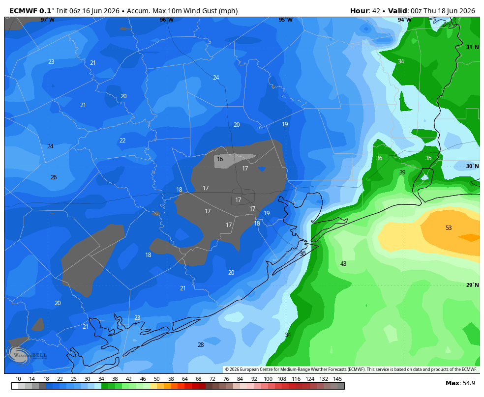
We are also likely to see some coastal wind gusts of about 30 mph, starting early Wednesday morning. I’m not sure how far inland these will extend, but it’s possible they could reach areas such as Pearland or League City. (Again this is dependent on the tropical system’s track). Water levels will also be 1 to 3 feet above normal tide levels, so there could be some minor coastal flooding. High temperatures on Wednesday should be in the upper 80s.
Thursday and Friday
At this time we expect rain chances to step back on Thursday and Friday, likely back into the 40 percent range. These likely would be more of your typical summertime showers and thunderstorms rather than anything too serious in terms of flooding potential. Highs will likely reach the lower 90s with more sunshine.
Saturday, Sunday, and beyond
The weekend looks to be partly to mostly sunny, with high temperatures in the lower 90s. There probably is about a 40 percent chance of rain on Saturday (hard to have too much confidence one way or other here), with lower chances on Sunday. Most of next week will probably see highs in the lower 90s, with the potential for scattered showers but fairly low chances overall. Basically it should be a return to normal programming for June in Houston.